Tricky but fun west swell, then OK down South
South Australian Surf Forecast by Craig Brokensha (issued Monday June 10th)
Best Days: Today South Coast, Mid Coast Wednesday and Thursday morning, selected spots South Coast Thursday through Sunday South Coast
Features of the Forecast (tl;dr)
- Small mid-period S/SW swell building tomorrow along with some local windswell on the Mid Coast with strong NW tending W/NW winds
- Moderate sized mid-period W'ly swell building Wed, easing Thu
- Weak S/SW swell for the South Coast Wed
- SW tending S/SE winds down South Wed (possibly variable early), S-S/SE tending weak sea breezey on the Mid
- Moderate sized S/SW swell Thu with moderate E/NE-NE tending SE winds
- Easing swell Fri with fresher E/NE-NE winds
- Smaller Sat with fresh E/NE-NE winds
- Inconsistent SW groundswell Sun with E/NE-NE winds
Recap
The South Coast was small and clean most of the weekend, while the Mid Coast saw tiny surf Saturday, pulsing yesterday to a better 2ft with workable winds and fun conditions.
This morning the swell looks to have eased a little quicker than expected with tiny leftovers in the gulf, small and clean down South.
This week and weekend (Jun 11 - 16)
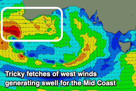
We’ve got a very dynamic but tricky week of winds and swell, improving later week as a very broad, stretched out mid-latitude low pushes in from the west.

The swell generating potential of this low for the Mid Coast now looks smaller, with the fetch of westerly winds being cut in half by the Margaret River region and it being angled more W/NW than anything.
With this we should still see a 2ft wave developing in the gulf through Wednesday, but ahead of this tomorrow, we’re looking at small surf with a building mid-period S/SW swell down South to 2ft+ through the day with strong NW tending W/NW winds.
Come Wednesday, the backside of the low looks to bring SW tending S/SE winds due down South along with a localised increase in windswell, while the Mid should see a morning S-S/SE breeze ahead of weak sea breezes, back SE on dark.
On Thursday, we’re due to see some stronger mid-period S/SW swell filling in across the South Coast, generated by a strong polar frontal system that’s currently south of us. This will project a fetch of strong to gale-force W/SW-SW winds up through our southern swell window, towards the eastward moving mid-latitude low, bringing a good spike in swell to 4ft+ across the South Coast, while the Mid looks to ease back from 1-2ft.

Winds should swing back to the E/NE-NE on Thursday down South, E-E/NE on the Mid with variable sea breezes in the gulf, smaller Friday.
Now, the wind outlook from Friday into the weekend and early next week depends on how the remnants of the mid-latitude low and polar front evolve once moving into the Tasman Sea.
Both global wave models have it forming into a broad low across the southern Tasman Sea, even possibly retro-grading back to the west and what this means is dicey conditions for us until it fully clears to the east or weakens.
With the slow movement of the low, it looks to keep a high pressure system to our west, resulting in persistent E/NE-NE winds Friday, Saturday and Sunday through the mornings.
This will be with easing levels of swell, with a fun pulse of long-range energy due Sunday for the South Coast.
The longer term outlook through next week remains slow thanks to the blocking effects of the high to our west, so try and work the incoming swells.

