Good run of swell continues for both coasts
South Australian Surf Forecast by Craig Brokensha (issued Friday June 7th)
Best Days: Both coasts tomorrow and Sunday, South Coast Monday, Mid Coast later Wednesday and Thursday morning, South Coast Thursday and Friday
Features of the Forecast (tl;dr)
- Easing W/SW swell tomorrow with NE-N/NE tending variable winds on the Mid, NW-W/NW down South
- Moderate sized W/SW swell Sun with N/NE tending N winds on the Mid, W/NW-NW down South
- Easing swell Mon with freshening N/NE tending N winds
- Smaller Tue with gusty W/NW winds
- Building W swell with W-SW tending S winds
- Peak in W swell Thu Am, easing with N/NE-NE winds
- Moderate sized S/SW swell Thu, easing Fri
Recap
The Mid Coast persisted around 1.5ft yesterday with morning offshores and weak sea breezes, while this morning, our new inconsistent W/SW groundswell provided similar sized surf. There’s a bit more consistency and a touch more size now showing with the incoming tide under variable winds.
The South Coast has seen variable winds and slightly lumpy conditions the last couple of days, hanging in the 2-3ft range across Middleton.

Glass this morning
This weekend and next week (Jun 8 - 14)
The current swell is due to ease back slowly tomorrow but the Mid Coast is likely to persist around 1.5ft with Middleton easing slowly from 2-3ft.
Winds tomorrow will have a bit more north in them, adding small bumps on the Mid Coast though variable into the afternoon. NW-W/NW winds look to persist all day down South.
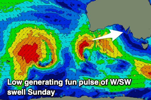
Winds will play out similar on Sunday, though W/NW tending variable NW down South during the day and N/NE tending N’ly in the Mid Coast along with a fun new pulse of mid-period W’ly swell.
The source is a mid-latitude low that formed west of Western Australia, just north of our swell window, drifting south-east this morning and more into our western swell window while generating a tight fetch of strong to near gale-force winds.

This should generate a great 2ft+ of swell in the gulf with Middleton coming in at 3ft, easing slowly Monday from 1-2ft on the Mid and 2-3ft down South.
Winds will freshen from the N/NE-N during Monday, favouring the South Coast and adding lots of bumps and chops across the Mid Coast.
The strengthening wind will be associated with a tricky mid-latitude low moving through the Bight, with a burst of strong W winds likely to generate a short-lived pulse of W’ly swell later Wednesday and more so Thursday morning to 2ft on the Mid Coast.
It won’t be favourable for the South Coast, but a stronger polar front should generate a good, moderate + sized pulse of S/SW groundswell for Thursday.
This will form under the country early next week, with a good pulse to 4ft due across Middleton, easing through Friday.
Winds at this stage look SW tending S on Wednesday as the low clears, quickly swinging back to the N/NE-NE on Thursday, with Friday seeing N tending W/NW winds as the next system clips us.
The outlook is slower following this swell so try and work around making the most of it. Have a great weekend!


Comments
Hey Craig, Robe and Beachport have been a bit unders Friday and Saturday morning. Is that always the case or was there a case of swells combining in the model or something?