Fun west swells continue
South Australian Surf Forecast by Craig Brokensha (issued Wednesday June 5th)
Best Days: Mid Coast for the keen tomorrow morning but more so Friday, Saturday and Sunday, South Coast every day
Features of the Forecast (tl;dr)
- Easing W/SW swell tomorrow with variable offshore winds ahead of sea breezes
- Inconsistent mix of new W/SW swells Fri with variable offshore winds ahead of sea breezes
- Easing swell Sat with NE tending NW winds
- New small-moderate sized W/SW swell Sun with moderate N/NE tending variable N winds on the Mid, early W/NW tending S down South
- Easing swell Mon with freshening N/NE-N winds
- Small Tue with stronger N/NW winds
Recap
Our fresh, expected pulse of W/SW groundswell filled in through yesterday with fun though bumpy 2ft waves on the Mid Coast, best through the morning before being swallowed up by the big afternoon high tide.
This morning conditions were much cleaner along with 2ft+ of swell persisting in the gulf but it’s not on the way out along with that big tide again.
The South Coast built to 3ft on the sets through yesterday, with similar sized waves into this morning with clean conditions ahead of a shallow SW change.

More dreamy surf in the gulf this morning
This week and next (Jun 6 - 14)
Our current W/SW swell will ease into tomorrow and conditions looks favourable for both coasts again, variable offshore before sea breezes kick in. The Mid will be a tease though still likely 1-1.5ft with Middleton backing off from a slow 2ft+.
A mix of inconsistent W/SW groundswells are then due to fill in Friday, generated by weaker, more distant frontal activity compared to the storm linked to the current swell.
We should still see fun but inconsistent 1-2ft sets across the Mid Coast with Middleton only likely to get to an inconsistent 3ft, with the models incorrectly combining swells and over-forecasting the size.
Winds look variable tending light offshore again ahead of weak sea breezes, similar Saturday but more northerly in bias, tending NW across all locations into the afternoon as the swell eases.

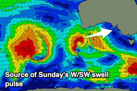
Come Sunday, a small-moderate sized pulse of reinforcing mid-period W/SW swell is due, generated by a small low forming off the tip of Western Australia Thursday afternoon. A tight fetch of strong to at times gale-force W/SW winds are initially due under Western Australia, dipping south-east through Friday, away from the Mid’s swell window and a touch better into the South Coast’s.
Size wise, a fun pulse to 2ft should be seen in the gulf again with 3ft sets across Middleton, easing into Monday.
Winds on Sunday will be best at dawn down South ahead of a trough with a W/NW tending S breeze due, moderate N/NE in the gulf, going variable from the N’th into the afternoon.
Fresher N/NE winds on Monday will favour the South Coast as the swell eases, with a shift in winds to the north-western quadrant due on Tuesday as another mid-latitude systems approaches from the west.
Looking at the middle of the week, and the models diverge regarding the merging of a mid-latitude trough and polar low with GFS going much stronger than EC which whisks it by rather quickly.
At this stage we’re looking at no real swell from the mid-latitude system with some good S/SW groundswell from the polar low along with favourable winds for the South Coast. More on this Friday.

