Tricky for the coming days, improving from later week conditions wise
South Australian Forecast by Craig Brokensha (issued Monday April 29th)
Best Days: Every morning South Coast from Thursday through next week, Mid Coast Sunday and Monday morning
Features of the Forecast (tl;dr)
- Moderate sized mid-period S/SW swell tomorrow and Wed AM, easing
- Gusty E/SE tending strong S/SE winds tomorrow, moderate E/SE Wed AM
- Smaller Thu AM with E/NE tending gusty S/SE winds
- Small-mod sized mid-period S/SW swell for late Thu and Fri AM, easing
- Local S/SE windswell also in the mix later week
- E/NE tending S/SE winds Fri/Sat/Sun
- Inconsistent long-range W/SW groundswell building slowly Sun, easing Mon
- Better, more consistent mid-period W/SW swell Sun, easing Mon
- E/NE-NE tending S/SE winds Mon
- Small-mod sized S/SW groundswell for late Mon and Tue AM
- N tending S winds Tue
Recap
A pumping weekend of surf on the South Coast with great conditions and a good sized swell Saturday, fun again yesterday but smaller. The Mid Coast was tiny and only suitable for beginners.
This morning the swell has reached a low point along with a cool, onshore change across the South Coast, tiny and peaky in the gulf.
This week and weekend (Apr 30 – May 5)
Today's change is linked to a swell generating cold front clipping the state, with moderate levels of mid-period S/SW swell due from later today through tomorrow and Wednesday morning.
A broad fetch of strong winds should kick up 3-4ft of S/SW swell for the coming days, with tiny 0.5ft to occasionally 1ft sets in the gulf.
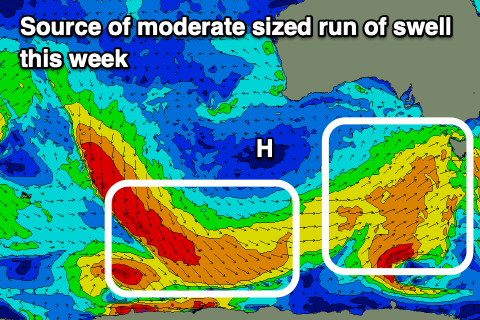
Unfortunately a significant high pressure cell will move in behind today's change, setting up camp in the Bight. This will see polar fronts firing up late in our southern swell window while persistent SE winds blow across the state.

Tomorrow's and Wednesday morning's swell will be met with poor, gusty E/SE tending strong S/SE-SE winds, weaker Wednesday morning but still E/SE in direction.
Thursday morning looks cleaner with an E/NE offshore due but expect peaky conditions and smaller surf to 2-3ft across Middleton, tiny inside the gulf.
Later in the day Thursday and Friday morning, a small-moderate sized pulse of mid-period S/SW swell is due, generated by a healthy but poorly aligned fetch of strong to gale-force W/NW tending W winds swinging in and along the polar shelf today and tomorrow.
An inconsistent pulse of S/SW swell 3ft wave is due across Middleton later Thursday and Friday morning, easing into the weekend from 2ft. The Mid won't see any swell from this source.
Winds should dip E/NE again on the South Coast Friday morning ahead of sea breezes with Saturday and Sunday playing out similarly.
Into Sunday a very inconsistent, long-range W/SW groundswell is due to slowly build, peaking into the evening and then easing into Monday morning.
The source is a strong but very distant frontal progression pushing up through the Indian Ocean from under South Africa.
Due to the large distance between the source of the swell and our region we'll see a lot of swell decay and loss in consistency but we should still see infrequent 3ft sets off Middleton Sunday afternoon and 2-3ft Monday morning, with 1-1.5ft sets on the Mid Coast.

Also in the mix Sunday across the Mid Coast will be some closer-range swell, generated by a tight low forming off Western Australia late week.
A stalling fetch of strong to gale-force W/SW winds should generate a bit more size out of the W/SW for Sunday coming in at 1-2ft, fading from 1-1.5ft on Monday.
E/NE-NE winds will favour both coasts on Monday morning as the swells ease with better N'ly winds Tuesday with another pulse of inconsistent S/SW groundswell likely (arriving late Monday). We'll take a closer look at this on Wednesday.


Comments
Congrats on the bubs mate, glad to have u back.
Congrats coat hanger!
Roche! Long time, cheers!
Also thanks Andy. The next chapter begins.