Only one day of cleanish conditions
South Australian Surf Forecast by Craig Brokensha (issued Wednesday November 22nd)
Best Days: Saturday morning South Coast
Features of the Forecast (tl;dr)
- Gusty S/SE tending S winds tomorrow with a moderate sized mix of S/SW and S/SE swells
- Easing surf Fri with fresh S/SE tending weaker SW winds early PM, stronger into the evening
- Small easing mix of swells Sat with gusty W/NW-NW winds, shifting SW and then S/SW into the afternoon while strengthening
- Moderate sized S/SW groundswell Sun with strong S/SE winds
- Building S/SE windswell through next week with strong S/SE winds
Recap
Small, average surf to kick off yesterday down South, becoming messier during the day thanks to strengthening S/SE winds. Today there's a bit more size to the S/SE windswell but with generally average conditions. The Mid Coast has been tiny and mostly unsurfable.
This week and weekend (Nov 23 - 26)
With a poor run of surf and winds due for the coming period (Saturday withstanding), it's worth looking at the broader synoptic setup that's driving it.
The main driver is persistent high pressure sitting south of Western Australia and through the Bight, only weakening temporarily later this week before another system slides in and takes its place through the weekend and early next week.
With the north-eastern arm of the high sitting across the Victorian region and inland instability tightening pressure gradients, we'll see persistent winds from the south-eastern quadrant along with smaller background swells.
It won't be a total write-off though with a window of cleaner conditions due Friday and Saturday as we fall in between highs.
Tomorrow will be poor but still in the 3ft range across the South Coast with a mix of new mid-period S/SW swell and S/SE windswell along with gusty S/SE-SE winds, shifting S through the day.

Smaller, easing surf is due Friday but with varying winds, shifting from fresh S/SE through the morning to the SW into the afternoon while easing, strengthening again later. This window of lighter winds likely won't be enough to provide any quality surf, but Saturday is still looking worthwhile thanks to a fresh W/NW-NW breeze.
Size size, a small mix of easing S/SW and S/SE swells to 2ft+ are due, best in protected spots, and deteriorating into the afternoon as winds shift SW, then S/SW while strengthening.
From here on in the new high will edge in, bringing a run of strong S/SE winds from Sunday, extending through nearly all of next week, only easing possibly Friday next week.
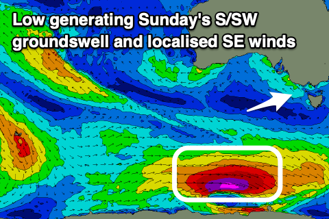
A moderate sized S/SW groundswell will be spoilt by these winds on Sunday (generated by the low pictured above), while localised S/SE windswell will come in with a bit of size. Unfortunately the Mid Coast isn't due to see any swell at all. More on this Friday.


Comments
Anyone want to chip In for a wave pool?
Any news on the Adelaide wavepool project near the airport?
Oh baby I got the south east blues.
It's a long song.
Time to make those summer plans, then it could be one of those 12 week affairs
Pity one of the best SA waves in a southeast is over run with seals.
Cull them I reckon.
Wouldn't mind some seal skin ugg boots.