Tricky winds with some fun swell to end off the week
South Australian Surf Forecast by Craig Brokensha (issued Wednesday September 27th)
Best Days: Thursday ahead of sea breezes (late Mid Coast), Friday South Coast (early Mid), South Coast Saturday and Monday for the keen
Features of the Forecast (tl;dr)
- Low point in swell Thu AM, with a new, moderate sized W/SW groundswell and mid-period SW swell building into the PM, peaking Fri AM
- Local offshore winds Thu AM ahead of relatively weak sea breezes
- N/NW winds Fri, freshening a little into the PM (E/NE-NE early on the Mid)
- Strengthening N/NW winds Sat with easing SW surf
- SW change moving through Sun with small surf
- Small, weak swell Mon with N/NE winds
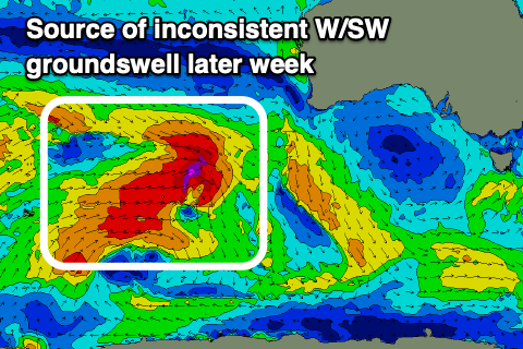
- Larger W/SW groundswell energy mid-late next week with dicey winds
Recap
The South Coast offered a lift in swell and lumpy 2-3ft surf yesterday ahead of afternoon sea breezes while the Mid Coast was a fun 1-1.5ft with the cleanest conditions found through the morning.
Today the swell is easing with lumpy 1ft+ waves left on the Mid Coast, 2-3ft and onshore down South thanks to a trough moving through yesterday evening.
This week and weekend (Sep 28 – Oct 6)
Early tomorrow still looks to be a low point in swell energy ahead of a mix of new mid-period SW swell and long-range W/SW groundswell arriving through the afternoon.

The mid-period energy has been generated by the remnants of the strong frontal progression linked to the groundswell energy, tracking under the country while generating off-axis fetches of W/NW winds.
The groundswell has come in well across the Margaret River region today and we should see it building to 3ft+ later tomorrow across Middleton with a peak Friday morning to 3-4ft, while the Mid Coast comes on at 1-1.5ft.
Winds tomorrow morning should be variable, tending light offshore across the Mid Coast, with relatively weak sea breezes moving in after lunch.
Friday looks great on the South Coast with a light N/NW offshore wind, increasing a little and holding into the afternoon. The Mid will be best at dawn with an E/NE-NE breeze before going more N'ly.
Into the weekend strengthening N/NW winds will favour the South Coast as the mix of swells ease back from the 3ft range across Middleton, tiny on the Mid Coast.
Sunday looks smaller again and a trough will bring a fresh SW change, making it a lay day.

Some small, weak windswell will be generated by Sunday's change for Monday but not above 2ft across Middleton and N/NE winds will create clean conditions but it'll be very weak and lacking power.
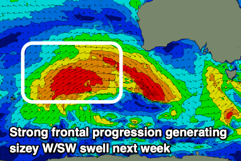
The remainder of the week will see some stronger W/SW groundswell moving in, generated by a strong, slow moving Southern Ocean frontal progression pushing up and across Western Australia.
The remnants of the progression might arrive at the same time as the swell through next week, bringing average winds and poor conditions so we'll have to have a closer look at this on Friday.

