Deteriorating conditions on the Mid Coast while the South Coast continues to fire
South Australian Surf Forecast by Craig Brokensha (issued Wednesday July 26th)
Best Days: Today both coasts, South Coast tomorrow and late Friday, South Coast Saturday, South Coast Sunday morning, South Coast Monday, both coasts Tuesday
Features of the Forecast (tl;dr)
- Easing surf Thu with strengthening N/NE tending N/NW winds
- Low point in swell Fri AM with fresh NW winds
- Moderate sized, mid-period S/SW swell building late Fri, peaking Sat AM with fresh N/NW-NW winds
- Moderate sized mid-period W/SW swell building Sun with NW tending W/NW and then late SW winds
- Stronger swell for Mon with mod-fresh NW tending W/NW winds
- Large W/SW groundswell for Tuesday with variable winds
Recap
A pumping day of waves across both coasts yesterday with a large mix of W/SW and SW groundswells filling in (biggest out of the SW late) along with all day favourable winds.
The Mid Coast was 2ft to occasionally 3ft, most consistent with the incoming tide while the South Coast kicked to a strong 6ft across most exposed breaks. There were a couple of weird double-ups thanks to the swells interfering with each other but for the most part, good quality waves were found all over.
This morning the swell is on the ease but still clean and to 4-6ft across the South Coast with good 2ft sets on the Mid Coast, but the wind has gone a little north adding some tiny imperfections (if we're to be fussy) in the gulf. Winds should tend N/NW and then ease across the Mid Coast mid-late afternoon with variable winds down South, providing another full day of surf that's worth capitalising on.

Solid sets yesterday afternoon
This week and next (Jul 27 – Aug 4)
Make the most of the Mid Coast surf today as into the end of the week, we'll see the size becoming tiny while also being very wind affected thanks to a strengthening N/NE breeze.
The South Coast will be the pick tomorrow with gusty N tending N/NW winds and easing 3ft to likely 4ft sets across the Middleton stretch, smaller and to 2-3ft through the afternoon and back to 2ft Friday morning with persistent NW winds.

We're now looking at a slight upgrade in the mid-period S/SW swell due on Saturday, with it also due to arrive a touch earlier, late on Friday.
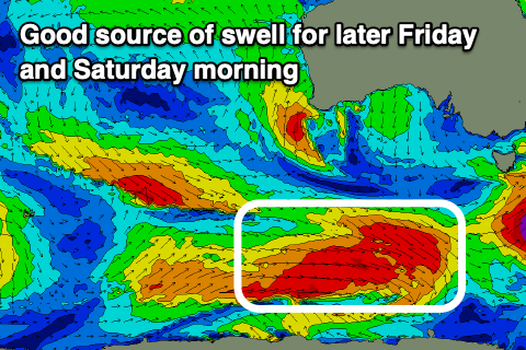
The polar frontal progression linked to it is currently producing a great fetch of W/NW gales through our southern swell window, with it likely to kick to 2-3ft on dark Friday across Middleton ahead of peak to 3-4ft Saturday morning. The source of the swell is too far south for the Mid Coast with tiny windswelly waves expected thanks to a gusty N/NW-NW breeze.
Into Sunday, some new mid-period W/SW swell is due from a flurry of strengthening mid-latitude frontal activity up and under Western Australia, then through the Bight.
This should come in around 1-2ft on the Mid Coast in the morning Sunday, building to 2ft through the afternoon with the South Coast missing out on most of the size and coming in around 3ft or so across Middleton.
A larger W/SW groundswell is expected to be produced by a much more robust fetch of back to back W/SW gales through our western and south-western swell windows on Saturday/Sunday.

This swell is due to build Monday and peak Tuesday with the Mid Coast at this stage due to come in at 3ft+ with 6ft surf off Middleton.
Local winds through this swell event will favour the South Coast initially, with a gusty NW tending W/NW breeze ahead of a late SW change due on Sunday, moderate to fresh NW tending W/NW on Monday.
We could get lucky Tuesday with variable offshore winds due to develop across both coasts as we fall in between fronts. This would create great conditions with the peak in swell energy but we'll confirm this Friday.

