West swells continue with varying winds
South Australian Surf Forecast by Craig Brokensha (issued Monday July 17th)
Best Days: Both coasts today and Wednesday (morning Mid Coast), Friday South Coast (morning Mid Coast), Saturday morning South Coast
Features of the Forecast (tl;dr)
- Mix of moderate sized swells tomorrow with fresh W/NW winds, tending SW late morning and S'ly later
- Easing surf Wed with freshening N/NE-NE tending N winds
- Low point in swell Thu with strengthening N/NW tending W/NW winds ahead of a late SW change
- Moderate sized + mix of W/SW groundswell and mid-period swell Fri with increasing NW winds
- Easing surf Sat with strong NW tending W/NW and then SW winds
- New mix of mid-period W/SW swells Sun with strong but easing S/SW winds
Recap
An average start to the weekend across both locations with an expected moderate to fresh onshore wind down South, while the Mid Coast was lumpy, small and weak with variable winds through the morning failing to really clean up some new W/SW swell.
The Mid got a little better through the day with inconsistent 2ft+ sets and generally light winds, better yesterday with cleaner conditions and fun sets hanging in at 2ft+. The South Coast also offered much cleaner conditions and a strong pulse of swell was seen through the day, holding 4ft this morning with excellent conditions. The Mid is also hanging in at 2ft with early light winds now freshening from the N'th.

South Coast on the pump this morning
This week and weekend (Jul 18 - 23)
We're expected to see the current swell, generated by a strong low moving under the country Friday/Saturday easing off into tomorrow morning, while a weak front clipping us through the day is due to bring some weak, mid-period SW swell for the afternoon, easing Wednesday.
This front will bring fresh W/NW winds tomorrow morning, shifting SW late morning and then more S'ly through the late afternoon. The Mid Coast looks to drop back to 1-2ft, with bumpy morning conditions, improving later while we'll see the South Coast holding the 3ft to occasionally 4ft range across Middleton but cleanest early.
Wednesday will see winds quickly shift around to the N/NE and freshen, likely tending more N'ly late afternoon along with easing levels of weak swell from 1ft to possibly 2ft on the Mid Coast and 3ft across Middleton.

Thursday will be a lay day with strengthening N/NW winds that will shift W/NW through the day ahead of a late SW change.
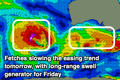
This change will be linked to a strong mid-latitude frontal system pushing in from the west, bringing with it a mix of W/SW groundswell and mid-period W/SW swell Friday.
This frontal system is currently in the form of a significant low pressure system to the west-southwest of Western Australia, with it generating a fetch of gale to severe-gale winds while moving slowly east. It's expected to weaken and split on approach to Western Australia, resulting in an inconsistent but strong W/SW groundswell for Friday that's due to arrive later Thursday, peaking Friday.
There'll also be some mid-period energy in the mix from the front pushing through Thursday with the Mid Coast due to come in at 2ft to occasionally 3ft with the South Coast providing inconsistent 4ft+ sets.
NW winds are due all day Friday, freshening into the afternoon, favouring the South Coast while winds will quickly shift from a strong NW'ly to the W/NW and then W/SW through the day Saturday as the swell eases, thanks to the next frontal system moving in from the west.
A renewal of moderate sized + mid-period W/SW swell is due on Sunday following this front on Saturday, though winds look dicey and strong but easing out of the S/SW. We'll confirm this on Wednesday.
Longer term, we're looking at a strong, moderate + sized W/SW groundswell for early next week, generated by a significant storm in the southern Indian Ocean. More on this Wednesday.

