Poor run of winds and surf
South Australian Surf Forecast by Craig Brokensha (issued Monday January 3rd)
Best Days: Mid Coast for bigger boards on the favourable parts of the tide today and tomorrow, South Coast possibly Sunday morning, Mid Coast Monday
Features of the Forecast (tl;dr)
- Mid-period W/SW-SW swell continuing tomorrow with strengthening S/SE winds
- Junky S'ly windswell from Wed through Fri with strong winds from the southern quadrant
- Mid-period SW swell building Wed PM, easing Thu
- Inconsistent, mid-period SW swell building Sun, peaking Mon with SE tending S/SE winds (likely E'ly for a period down South Sun AM)
Recap
Saturday morning offered a window of light winds and clean conditions down South but the swell was tiny and only for bigger boards across the swell magnets ahead of an onshore change. This created poor surf into yesterday with no change in size.
Today our first pulse of mid-period W/SW swell is in the water but the high tide is doing its best to stop it breaking on the Mid Coast with 1-1.5ft lines that are hardly capping. The South Coast is small and choppy today with the onshore breeze.

Tiny, full sets this AM
This week and weekend (Jan 4 - 9)
Try and make the most of the tiny 1-1.5ft of swell on the Mid Coast today and tomorrow as the rest of the forecast period is void of any decent swell for the gulf, and we're set for a poor, extended run of onshore winds across the South Coast.
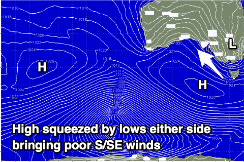
The synoptic setup responsible for this poor run is a hyrbid low sitting off the East Coast, nestled between a high pressure system over New Zealand and a high setting up south-west of us. With the low there the high can't edge in further to the east, with deepening inland instability squeezing the high to our south-west. There'll also be a broad polar low forming south-west of the high, adding more of a squeeze across us.
 This will bring strengthening S/SE winds through today that will persist tomorrow and Wednesday (though easing off back to moderate to fresh temporarily tomorrow morning).
Thursday looks to see winds ease back to a moderate S'ly before shifting S/SW and strengthening again as the inland instability slips south across Victoria, bringing that wind change.
Strong S/SW winds will then persist through Friday, easing a touch and swinging back to the S/SE on Saturday as a new high pressure system starts nudging in from the west.
What this signals is a poor run of surf all week with moderate levels of windswell out of the S'th, coming in either side of 3ft. There'll also be some new, mid-period SW swell building Wednesday, easing Thursday but it's a moot point and won't be noticed under the local onshore winds and windswell. The Mid Coast will only be 1-1.5ft tomorrow back to 1ft max Wednesday through Friday.
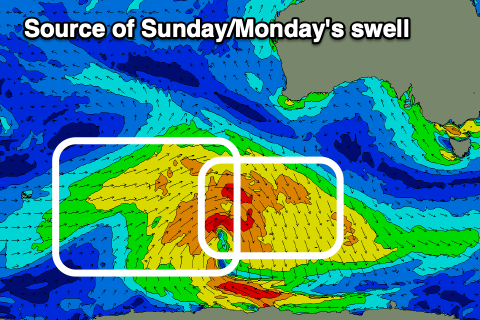
 Moving into Sunday we may see winds tip back to the E along with a new, mid-period SW swell generated by a broad but generally weak polar low firing up south-west of Western Australia on Wednesday. We'll see a pre-frontal fetch of strong to near gale-force W/NW winds giving way to similar strengthen post-frontal W/SW winds, with an increase Sunday, easing slowly from a peak Monday morning.
It looks to build to 3ft across Middleton on Sunday, easing from a similar size Monday while the Mid Coast looks to come in at 1-1.5ft Monday.
With that morning E'ly wind Sunday, the swell looks a bit smaller and to 2ft to maybe 3ft down South, while Monday may see winds revert back to the SE. We'll have a closer look at this Wednesday.

