Slow end to the year
South Australian Surf Forecast by Craig Brokensha (issued Wednesday December 29th)
Best Days: Swell magnets tomorrow morning, similar Friday but for the desperate, Mid Coast for bigger boards Monday
Features of the Forecast (tl;dr)
- Small mix of S/SW and S/SE swells tomorrow with variable N/NE tending S/SE winds
- Fading mix of tiny swells Fri with N/NE tending fresh N/NW winds ahead of a mid-afternoon SW change
- Small-moderate sized, mid-period SW swell building late Sun, peaking Mon with strong S/SE winds
- Easing swell Tue with strong SE tending S/SE winds
- Slightly better, reinforcing SW swell later Tue, peaking Wed with strong SE tending S/SE winds
- Poor S/SE windswell Mon through Wed
Recap
Monday afternoon's solid kick in S/SE windswell eased off a touch into yesterday morning but it was still chunky and to 3-5ft with poor, onshore winds. Today the swell has backed off a bit more along with the wind, offering surfable 2-3ft waves for the desperate. The Mid Coast has remained tiny to flat.
This week and weekend (Dec 30 – Jan 2)
Over the coming days we've got cleaner conditions on the cards with a high that's been dominating our weather and winds since the weekend due to weaken its grip across the state.
Swell wise it'll be minimal and the swell magnets are the pick while Middleton and Goolwa will be ideal for beginners.
Looking at tomorrow and a variable N/NE breeze is due across the South Coast in the morning with a small, new mid-period S/SW swell. This swell will be inconsistent and weak with sets to 2ft across Middleton and 2ft+ waves across the swell magnets. There'll also be 2ft of easing S/SE windswell in the mix.
Friday will be clean with a light to moderate N/NE offshore, shifting N/NW and freshening ahead of a mid-afternoon SW change. Unfortunately the swell will be small to tiny, fading from 1-1.5ft across Middleton and possibly 1-2ft across those exposed beaches.
Come Saturday there's a chance for dawn N'ly winds ahead of a trough and change but swell wise it'll remain tiny, so tick this one off the list.
Sunday looks to be a lay day with strengthening S-S/SW winds as a high moves in from the west along with no new swell until late in the day.
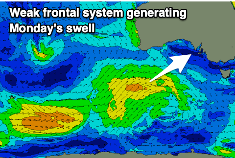
This new SW swell will be mid-period in nature and on the weaker side of the coin. It'll be generated by a broad but relatively weak frontal progression projecting up and under Western Australia over the coming days, weakening through the weekend.
 The swell looks a touch smaller than forecast Monday with a late kick Sunday to 1ft+ on the Mid Coast, peaking Monday to 1-1.5ft. There might be the rare 2ft'er on the favourable parts of the tide but the cycle isn't favourable with the big high falling at dawn. The South Coast should see 2-3ft waves across Middleton but conditions will be poor thanks to a strong S/SE breeze. This will generate some new S/SE windswell which will likely be more noticeable.
Easing surf is expected into Tuesday with strong SE tending S/SE winds, but a reinforcing pulse of slightly better SW swell is on the cards for later in the day and Wednesday. This will be generated by a stronger, trailing low behind the weak frontal progression, though the swell direction looks less favourable for the Mid Coast.
We'll see onshore winds persist across the South Coast so all in all options will be very limited. Into next weekend winds are likely to improve but the swell will be small, weak and fading. Therefore make the most of tomorrow morning.


Comments
time to head to the East,depending on how many times the states and their so called Leaders change the rules of entry{again}
looks like if your keen for a surf, book yourself a flight to the goldy