Weaker swells to end the week, less than ideal winds for the weekend
South Australian Forecast by Craig Brokensha (issued Wednesday 11th October)
Best Days: Protected spots South Coast Thursday and Friday morning, Mid Coast for small peelers on the favourable tides Friday, keen surfers South Coast Saturday morning
Recap
Great waves across both coasts all day yesterday with a good clean 2ft swell on the Mid Coast with an afternoon glass-off and some bigger sets pushing in with the tide. The South Coast was clean all day but biggest and best during the morning.
The swell has dropped back into this morning leaving tiny choppy waves on the Mid Coast with a strengthening N'ly wind, while the South Coast was clean but windy with the stiff offshore.
This week and weekend (Oct 12 - 15)
Today's strengthening N'ly wind and subsequent W/SW change this afternoon is linked to a strong front pushing through the Bight and we'll see a late increase in W/SW windswell followed by some stronger mid-period energy tomorrow morning.
The Mid should offer 2ft waves, while Middleton looks to jump to the 3ft range across Middleton, with bigger sets down from Cliffs. Persistent W/NW winds will favour protected locations all day.
 The swell should hold a similar size into Friday down South as a secondary front moves through tomorrow, though our swell window this evening and early tomorrow. This front will be positioned a touch further south though resulting in less size for the Mid Coast with a drop back to 1-2ft on the favourable parts of the tide.
The South Coast forecast graph is incorrect as the wave model is incorrectly combing some distant long-period energy with the more localised swell. Expect Middleton to hang around 3ft. A morning W/NW breeze will tend S/SW across the South Coast into the afternoon while the Mid should see variable winds ahead of sea breezes.
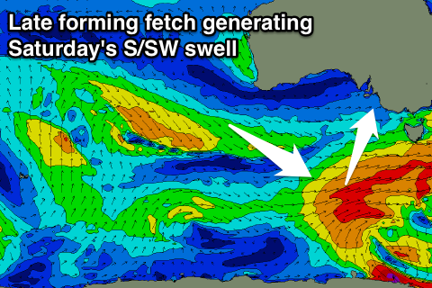
A final polar front developing late in our swell window, generating gale-force winds in our southern swell window. This should produce a fun S/SW groundswell for Saturday morning but only to 3ft across Middleton again, with the models over-forecasting the size, while the Mid will become tiny.
A light E'ly wind will create OK but not great conditions down South on Saturday, while Sunday will see E'ly winds with a bit more strength, creating average conditions.
Into early next week the swell will continue to fade with small to tiny surf developing across our regions as winds swing more NE.
A large blocking high will keep the state quiet until we see some new frontal activity starting to move in late-week, but more on this Friday.

