Fun weekend at swell magnets, good swell and winds Tuesday
South Australian Forecast by Craig Brokensha (issued Friday 6th October)
Best Days: Swell magnets South Coast Saturday and Sunday morning, both coasts Tuesday, South Coast Wednesday morning
Recap
Clean conditions with tiny 1-1.5ft waves on the Mid Coast yesterday morning, pulsing to 2ft on the sets into the afternoon with S'ly winds. The South Coast was poor but a solid S'ly windswell kicked through the day but with no quality.
This morning conditions were cleaner than yesterday but still sloppy and unorganised down South with an E/NE-E breeze and 3-4ft of S'ly swell. The Mid Coast was also clean but tiny.
This weekend and next week (Oct 7 - 13)
The surface trough responsible for the S'ly windswell down South has drifted east and will continue to do so as a ridge of high pressure moves in from the west.
We'll see the swell ease steadily through today, with not much left in the tank tomorrow morning. A new SW groundswell will take its place though, with 2ft to occasionally 3ft waves off Middleton, back to a smaller 2ft on Sunday.
A fresh NE tending lighter N'ly breeze will favour exposed breaks tomorrow, while Sunday will see NW-W/NW tending W/SW and then SW winds.
The Mid Coast is expected to become tiny to flat tomorrow, with tiny dribbles of swell on Sunday.
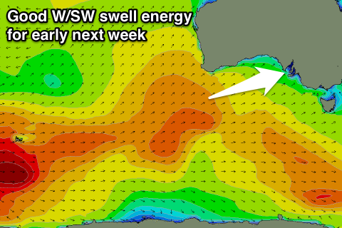
 Of greater importance are the W/SW swells due into early next week with back to back polar fronts forming in the Heard Island region and projecting towards WA expected to generate back to back W/SW swells.
The first front is now weakening south-west of WA, with the swell filling in Monday and coming in at an inconsistent 2ft on the sets across the Mid Coast, likely pulsing to 2ft+ on the afternoon incoming tide.
Middleton should see inconsistent 2-3ft sets and a W/NW tending W/SW breeze will favour protected spots during the morning.
The secondary front will generate a further pulse of W/SW energy on Tuesday that looks to be a bit stronger with 2ft to occasionally 3ft sets likely on the favourable parts of the tide across the Mid Coast (though a morning high isn't ideal) and 3ft to occasionally 4ft across Middleton during the morning, easing through the day.
A high will move in Tuesday resulting in great conditions across all spots with a light local offshore wind, tending northerly and then variable into the afternoon.
The swell will ease Wednesday with strengthening N/NW tending W winds as a strong mid-latitude front approaches from the west.
This mid-latitude activity looks to generate plenty of W/SW swell late week/into the weekend, but more on this Monday. Have a great weekend!

