Average tomorrow, great Friday with mixed conditions for the weekend
South Australian Forecast by Craig Brokensha (issued Wednesday 20th September)
Best Days: Friday early Mid Coast, all day South Coast, Saturday morning South Coast, Sunday afternoon South Coast
Recap
Early light onshore winds across the Mid Coast tended variable by mid-morning along with a good W/SW groundswell coming in at 2ft to occasionally 3ft. The late morning and early afternoon saw the most consistent 2-3ft sets with the incoming tide as winds remained variable.
The South Coast saw an early W'ly breeze and large inconsistent sets out on the coast out of the SW. Winds tended light to moderate onshore though and remained so until right on dark, while today is cooking. We've got a reinforcing long-period S/SW groundswell and offshore winds providing excellent waves across selected reefs, while the Mid Coast is still around 2ft but a bit wind affected.
This week and weekend (Sep 21 - 24)
This morning's large pulse of quality S/SW groundswell will ease this afternoon and drop further through tomorrow from 2ft to occasionally 3ft at dawn across Middleton.
Winds aren't looking too favourable with a shallow SW change due around dawn, though we may see a period of lighter W/NW winds around Victor at dawn. With better surf days to come, it's probably worth flagging.
The Mid Coast is due to be tiny through the morning and around 1ft, but we should see some late new W/SW groundswell, generated by a slow moving mid-latitude low that developed west-southwest of WA earlier this week.
This low is now sitting south of WA, aiming a great fetch of strong to gale-force but weakening W/SW winds through our western swell window, with it due to continue tracking south-east while weakening into this evening.
 We may see a late pulse in size to 1-2ft across the Mid Coast tomorrow with light SW breeze, but Friday should see fun 2ft sets, with the chance for the odd bigger one on the incoming tide. The South Coast should see 3ft waves off Middleton, easing a touch later in the day, down from 2-3ft Saturday (1-1.5ft Mid Coast).
Winds on Friday will be fresh from the N/NE, tending moderate N/NW into the afternoon, but the Mid Coast should see an early period of lighter breezes.
A NW tending strong W/NW breeze will then favour protected spots down South Saturday while kicking up a building windswell later in the day on the Mid.
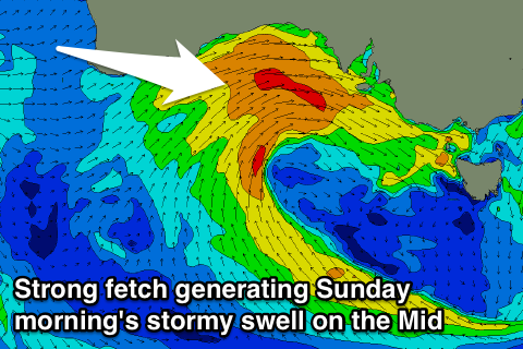
This strengthening W/NW breeze will be associated with a vigorous mid-latitude low moving in from the west over the coming days, with it due to produce a great fetch of W/SW gales through the Bight Saturday, moving across us into the evening.
This will generate a stormy W/SW swell for Sunday coming in around 3-4ft through the morning, easing off through the day with fresh to strong but easing W/NW winds.
The South Coast won't see any major size with the swell being super west resulting in close-spaced 3ft waves off Middleton with those favourable easing W/NW winds.
Monday will see the swell fade quickly with light morning winds ahead of a SE change as a ridge of high pressure moves in from the west. Longer term another mid-latitude low is forecast to move in mid-next week but it will be placed too far north to generate any swell at this stage.

