Plenty of swell for the South Coast, clean each morning
South Australian Forecast by Craig Brokensha (issued Monday 31st October)
Best Days: South Coast every day this week, Mid Coast Thursday for small to tiny runners
Recap
Great fun waves across the Mid Coast most of the weekend, best Saturday, while the South Coast was also best Saturday with offshore winds and clean 2-3ft sets off Middleton, better at Waits and Parsons.
Sunday was cold bumpy and less than ideal with a W'ly change.
Today this change has brought with it a new increase in mid-period W/SW swell to 2ft+ on the Mid and 3ft off Middleton down South. W/NW winds favoured protected locations down South.
This week (Nov 1 - 4)
Today's increase in mid-period W/SW swell is just the start of some better SW groundswells due over the coming few days across the state.
An elongated fetch of strong to gale-force W/SW winds are currently being drawn out between us and the polar shelf, south of WA.
The closest fetch of W/SW gales should produce a new SW groundswell for tomorrow, while a better aligned and more southerly located fetch moving up over the already active sea state should generate the largest increase in size Wednesday.
Tomorrow's swell will perform best on the Mid, with it having a touch less south in it than Wednesday's, with 2ft sets due on the favourable parts of the tide most of the day, easing from 1-2ft Wednesday.
The South Coast should see good 3-4ft sets off Middleton most of tomorrow, kicking a little into the afternoon, with Wednesday's swell coming in more around 4-5ft. Larger waves are due at exposed breaks.
From Thursday the SW swell should slowly fade away, slowed slightly by an unfavourable fetch of pre-frontal W/NW winds moving under the Bight tomorrow and Wednesday morning.
Middleton is likely to ease back but hold 3-4ft most of the day, easing only late, backing off more noticeably from 2-3ft Friday morning. The Mid is likely to offer 1-1.5ft sets Thursday, tiny from Friday.
 Winds over the coming days will favour protected spots like Middleton on the South Coast with a W/NW tending W/SW breeze both tomorrow and Wednesday. Thursday should be clean across both coasts with light local offshores ahead of afternoon sea breezes, more from the N/NW Friday ahead of a late W/SW change.
This weekend onwards (Nov 5 onwards)
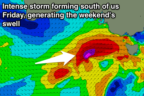
The fronts and storms will continue to come through the weekend, but we'll see an intense mid-latitude low forming under us and just clipping the state through the weekend.
With this a moderate to large sized increase in SW swell is due Saturday with average winds, easing quickly Sunday but with offshores as a ridge of high pressure slides in from the west. We'll have another look at this on Wednesday.

