Improving conditions over the weekend with easing surf. Mix of swells next week
South Australian Forecast by Craig Brokensha (issued Friday 7th October)
Best Days: South Coast spots that like east wind tomorrow, swell magnets early Sunday, South Coast Wednesday and Thursday mornings
Recap
OK 1-2ft waves across the Mid before the wind kicked up yesterday, while the South Coast saw great conditions with strong 4ft sets off Middleton along with N-NW offshores.
Today the swell is slowly easing and conditions were great down South early with an offshore wind, but a change has since moved through. The Mid Coast was a peaky 1-2ft.
This weekend and next week (Oct 8 - 14)
Tomorrow morning's new SW groundswell is still on track and winds are looking a touch better.
This swell is being generated by a mid-latitude frontal systems that's currently south of us, linked to this morning's onshore change.
Good 3ft sets are due at Middleton, more towards 3-4ft at Goolwa, with 1ft waves on the Mid. The swell will ease slightly into the afternoon and further through Sunday from a small 2ft at Middleton.
Winds will swing E/NE-NE down South tomorrow morning, creating peaky but improving conditions mid-late morning, likely tending E/SE into the afternoon at some stage.
Sunday will be best early with a gusty N/NE wind ahead of a W/NW change.
Now, the Mid Coast should see a late increase in windswell to 1-2ft or so from the strengthening W/NW breeze.
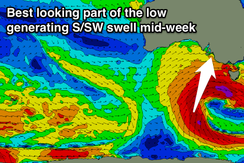
The interesting developments come into next week, with a vigorous and deepening mid-latitude low due to form south of us.
This low isn't that ideal a swell producer, with a lot of wind, but nor much strength ideally aligned in our swell window.
 An initial increase in W/SW groundswell is due across the Mid Coast Monday from a front pushing through the Bight over the weekend. This along with strong W/SW winds should produce 3ft of stormy windswell.
The South Coast should see building levels of windswell turning mid-period W/SW swell, from 2ft+ at Middleton early to 3-4ft later but with strong W/NW tending W/SW winds. Tuesday morning should see better 3-5ft waves off Middleton, while the Mid Coast is expected to ease back from 3ft.
The best swell in my opinion is due from the S/SW Wednesday afternoon and Thursday morning. This will be produced by a fetch of S/SW gales wrapping around the base of the low through our southern swell window.
This will also be met with more favourable winds, especially Thursday morning, but more on this Monday. Have a great weekend!


Comments
Couple of small peelers at the Superbank.
Next weds swell has wsw & ssw angles both similar period & height , are these distinct directions or is there perhaps a mix so that a sw swell could exist in amongst it ? Can some light be shone on this interesting situation weds , ( Thurs & fri too ) please craig
Ah sorry Camel, I missed this question.
Craig is best to answer - I haven't been looking at the Southern Ocean charts.
Looks like size has kicked a lot at Middleton since earlier.