Large good swell tomorrow, cleaner and great Sunday

South Australian Forecast by Craig Brokensha (issued Friday 19th August)
Best Days: South Coast experienced surfers tomorrow, South Coast Sunday through Tuesday, Mid Coast Wednesday
Recap
Tiny bumpy waves across the Mid Coast with a building NW windswell into the afternoon, while the South Coast was small and faded further through the day.
Today a mix of W/SW windswell and groundswell were building across the Mid Coast with poor winds, while the South Coast was small to tiny but cleaner.
We should see the Mid reaching 3ft+ through this afternoon as winds tend more W/SW. The South Coast should also build but the large stuff is due tomorrow morning.
This weekend and next week (Aug 20 - 26)
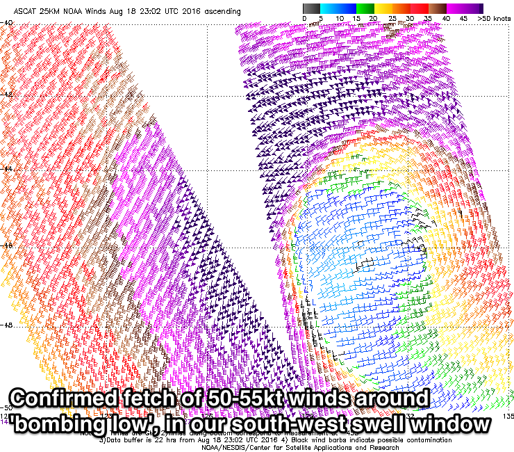 Over the last 24 hours we've seen a significant low pressure system 'bombing' in the Bight (dropping over 24hPa in less than 24 hours).
This has resulted in a fetch of storm-force W/SW-SW winds being aimed within our south-western swell window, confirmed by satellite imagery shown right.
This will generate a very large long-period SW groundswell event for us tomorrow morning, peaking early.
The low is currently weakening and drifting east-southeast towards Tassie, more into our southern swell window. This will result in the swell swinging more S/SW into Sunday while easing, and one final pulse of mid-period S/SE swell is due Tuesday afternoon from a stalling fetch of strong S/SE winds around the bottom of the low during the weekend.
Size wise, we're looking at large powerful 6-8ft sets across Middleton tomorrow morning with larger bombs at offshore reefs and Waits and Parsons, easing back steadily through the day, down from 4ft at Middleton and 5ft+ or so at Waits and Parsons Sunday morning.
The Mid Coast should see easing 3ft sets out of the W/SW tomorrow morning, with dropping 2ft waves Sunday as a weak fetch of W'ly winds remain positioned through our swell window tomorrow.
Conditions will be best in protected spots down South tomorrow with a moderate to fresh W/NW'ly, while Sunday looks excellent under N/NW winds, easing late in the day.
Into Monday the surf will be smaller and fading from 2-3ft at Middleton, 4ft at Waits with N/NW tending variable winds. The Mid should ease from 1-1.5ft.
The S/SE swell for Tuesday looks fun in size, building to 3-4ft across south facing breaks through the day, but winds will deteriorate with a deepening inland low to our east, resulting in fresh NE tending E/SE breezes. The Mid Coast is expected to kick slightly to 1-1.5ft from a distant W/SW groundswell, better into Wednesday around 1-2ft. but into the end of the week, conditions are looking poor with average windswell due to the stalling low to our east. More on this Monday though, have a great weekend!