Fun Mid Coast for the weekend, better South Coast from Wednesday
South Australian Forecast (issued Friday 25th December)
Best Days: Saturday afternoon and Sunday Mid Coast, South Coast Monday and Tuesday mornings, Wednesday and Thursday both coasts
Recap
Small clean waves for exposed spots across the South Coast yesterday, while the Mid was tiny ahead of an increase in new SW groundswell to an inconsistent 1-1.5ft through the afternoon. This swell has held in this morning around a similar size with some N'ly scarring, while the South Coast is the pick with solid but very inconsistent 3ft+ sets at Middleton and more size down towards Goolwa.
Conditions should remain clean down South until mid-afternoon ahead of a cool and gusty SW change.
Middleton early this morning taken by CL Photos

This weekend and next week (Dec 26 – Jan 1)
South Coast: Poor onshore SW winds will create average conditions across the South Coast tomorrow with a temporary drop in swell, ahead of a new pulse of W/SW swell into the late afternoon/Sunday morning.
This swell will favour the Mid over the South Coast, being generated by a strong frontal system projecting up towards WA and then through the Bight, moving in through this afternoon.
The Middleton stretch should kick to 3-4ft late, and ease from a similar size Sunday morning but with average SE-ESE winds.
Monday will be better but still peaky as the swell eases from 2-3ft at Middleton and 4ft or so at Waits under morning E/NE winds.
The easing trend should be stopped Tuesday as a small reinforcing W/SW swell fills in, keeping 2ft sets hitting Middleton and 3ft waves out at Waits and Parsons. Morning E'ly winds will again create peaky conditions.
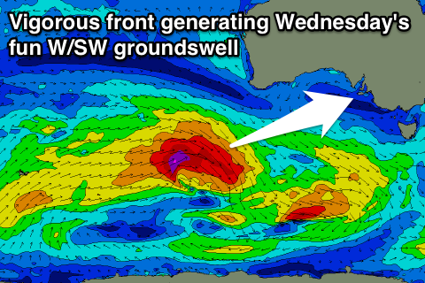
 Longer term some good W/SW groundswell is due into Wednesday and Thursday with favourable winds, as a strong frontal progression pushes up towards WA. A pre-frontal fetch of W/NW gales over an already active sea state should produce a good pulse of W/SW groundswell for Wednesday coming in at 3ft+ across Middleton with 4-5ft sets at Waits and Parsons with light morning N/NE winds.
Thursday should be be great as well as the swell slowly eases under N/NW offshores ahead of a late change.
Mid Coast: We're looking at a great weekend of waves, with improving conditions across the Mid. Tomorrow morning is due to be bumpy and around 2ft with fresh S/SW winds, with the good pulse of W/SW groundswell kicking to 2-3ft into the afternoon as winds swing S/SE late.
Sunday morning should then see easing 2ft to occasionally 3ft sets with offshore E/SE winds, down from 1-1.5ft Monday as offshores continue.
Tuesday is expected to offer tiny 1ft waves, with some better size Wednesday with the new W/SW swell to 1-2ft on the favourable parts of the tide, persisting Thursday and then slowly fading Friday. We'll have a closer look at this Monday though. Have a great Christmas!

