Fun weekend, good Mid Coast Monday
South Australian Forecast (issued Friday 18th December)
Best Days: Mid and South Coasts tomorrow morning, protected spots down South early Sunday, Mid Coast Monday and Tuesday morning, South Coast keen surfers Tuesday through Thursday mornings
Recap
Clean conditions and a fun mix of swells down South yesterday across swell magnets to 2ft with the odd bigger one with 0.5-1ft sets on the Mid. Today a better W/SW groundswell has moved in with 2-3ft sets at Middleton and more size out to the west, but conditions were average with an increasing onshore wind.
The Mid was better with clean conditions and fun 1-1.5ft peelers across most breaks.
This weekend (Dec 19 - 20)
South Coast: Today's pulse of W/SW groundswell should ease back through tomorrow across the South Coast from 2ft+ at Middleton and 3ft+ at Waits and Parsons with favourable and offshore N/NE tending N/NW winds ahead of late SW sea breezes.
A small reinforcing pulse of SW groundswell is due Sunday morning keeping similar sized surf to Saturday morning hitting the coast, but an early W'ly breeze will give way to an onshore change through the day, so protected locations will be the only decent option.
Mid Coast: Similar amounts of W/SW swell are due through most of the weekend between 1-1.5ft on the sets, while tomorrow will be the day to surf with early favourable winds, onshore into Sunday.
Next week onwards (Dec 21 - 25)
 A good pulse of W/SW groundswell is due Monday across the Mid Coast and less so across the South Coast, with some better aligned S/SW swell impacting down South at the same time.
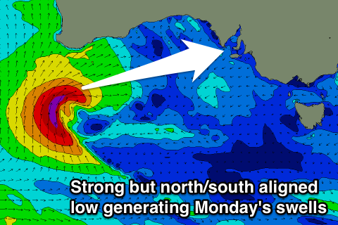
Both these swells will be generated by the one system, that being an intense mid-latitude low that's currently developing south-southwest of WA.
This low is now forecast to be initially favourably aligned for the Mid before the fetch takes a more north/south orientation as it pushes east through the Bight.
This will reduce the size and potency of the swell, but we should still see good 2ft+ sets across the Mid Coast Monday.
As the low pushes past us during Sunday a fetch of S/SW gales will be aimed towards the South Coast, kicking up a moderate sized S/SW swell to 3ft+ across Middleton and 4ft+ at Waits and Parsons. SE winds will unfortunately create poor conditions down South, with clean good waves on the Mid all day, with only S/SE breezes into the afternoon.
The swell should ease through Tuesday from 1ft to possibly 2ft on the Mid, and 2ft at Middleton with 3ft sets at Waits with slightly better but fresh E'ly breezes.
There's nothing significant due into Wednesday as winds continue from the E, while Thursday will be cleaner across the South Coast with a N/NE offshore but small swell only surfable at Waits and Parsons.
Of greater significance is some better SW groundswell due later next week and into the weekend as a strong and slow moving polar low develops south-west of WA under the influence of the Long Wave Trough. We'll have a closer look at this Monday though, have a great weekend!


Comments
Lovely lines on the Mid this morning.
Hey Ben:
Why is the Mid Coast swell forecast only saying 1 ft?
Primary swell size looks low too?
Our model needs a few tweaks to get the forecast graph to better represent the Mid Coast (should be deployed in the next few weeks). However it's an extremely difficult location to automatically forecast for as the models don't really capture the wave transformation through Investigator Strait properly. We're constantly trying to fine tune it, but it's a difficult task.
Small and crowded at foot