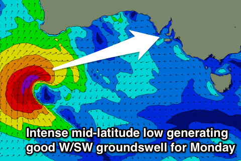
Small workable waves ahead of an excellent Mid swell Monday
South Australian Forecast (issued Wednesday 16th December)
Best Days: South Coast swell magnets Thursday morning, Mid Coast Friday and Saturday for longboard peelers, South Coast Saturday morning, Mid Coast Monday and Tuesday
Recap
Tiny surf across the Mid, with the South Coast providing similarly small but slightly more surfable and clean options at Waits and Parsons but only to 1-2ft or so.
Today similar amounts of swell were seen but with light onshore winds, while the Mid was effectively flat.
This week and weekend (Dec 17 - 20)
South Coast: Clean conditions are due down South tomorrow morning under a light N/NE wind along with a slight lift in SW groundswell. Middleton is due to only offer 1-2ft sets at best, with 2ft+ waves at Waits and Parsons the pick.
A slightly better but inconsistent W/SW groundswell should fill in Friday, generated by a strong and slow moving polar low to the south-west of WA the last few days.
Middleton should offer better 2ft+ sets through the day Friday, with 3-4ft waves at Waits and Parsons, but those forecast onshore winds aren't budging, with a fresh and gusty S/SE'ly due from dawn.
Saturday will be the day to surf over the weekend as winds swing offshore from the N/NE to N/NW and the swell drops from a small 2ft on the sets across Middleton and 3ft at Waits and Parsons. Conditions may stay clean all day, but more than likely a mid-afternoon sea breeze will develop.
Sunday looks poor with a fresh W'ly tending SW breeze as a mid-latitude low moves through the region and the swell remains small and inconsistent.
Mid Coast: A very slight kick in background swell to 0.5-1ft is due tomorrow with clean conditions, while Friday through Sunday should see more size to 1-1.5ft as the W/SW swell fills in from the slow moving low. Good conditions are due each day before those onshore winds move in Sunday.
Next week onwards (Dec 21 onwards)
 An intense mid-latitude low forming south-southwest of WA during Friday afternoon and evening will produce two separate pulses of swell. The first will be very west in nature and best for the Mid as a fetch of gale to severe-gale SW winds are aimed towards the Bight.
The low will then weaken while pushing east over the weekend, re-strengthening late in the South Coast's southern swell window. This will generate only a relatively small reinforcing S/SW groundswell for Tuesday morning, easing through the day.
South Coast: The W/SW swell is due to peak Monday morning with good 3ft at Middleton with 4-5ft sets at Waits and Parsons, easing through the day, with the S/SW swell for Tuesday morning keeping 2-3ft waves hitting Middleton early, with 3-4ft sets at Waits and Parsons, easing through the day. Unfortunately fresh to strong SE winds will create poor conditions Monday with slightly better but still less than ideal E'ly winds Tuesday.
Mid Coast: The W/SW swell for Monday should provide great 2-3ft waves across the Mid during the morning, easing into the afternoon and further down from 2ft Tuesday.
Longer term we may see some good SW groundswell for later in the week and more so next weekend, but we'll have another look at this Friday.


Comments
The Surf Forecast Swell Train Analysis at http://www.swellnet.com/reports/australia/south-australia/mid-coast/fore... is saying 1ft all day Mon 21/12??
The Mid Coast automated forecast always is known to undercall size all the time, and we've got a fix to bump up the figures in the near future.
In saying this the structure of the low has changed a little and the westerly aspect of the fetch is looking a little less favourable. We should still see at least 2ft surf Monday morning though.