Bumpy Mid Wednesday, better South Coast Thursday
South Australian Forecast (issued Monday 7th December)
Best Days: Wednesday and Thursday morning keen surfers on the Mid, Thursday down South, Mid Coast Saturday for keen surfers, South Coast Sunday
Recap
Nothing to really surf on the Mid but great conditions for beginners and a dip, while the South Coast was best at swell magnets with hot and light offshore winds and glassy conditions, while yesterday was tiny.
Today clean conditions were seen again down South with a fun small swell for exposed breaks, while the Mid was effectively flat.
This week (Dec 8 - 11)
South Coast: Clean conditions are due again tomorrow with a fresh NW tending W/NW breeze, but the surf is due to be tiny. Waits may pick up 1-2ft waves, but it's not worth the drive from Adelaide.
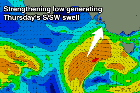
 Into Wednesday and Thursday a mix of small W/SW veering S/SW swell is due, along with a long-range and inconsistent SW groundswell. The W/SW tending S/SW swell will be generated by a deepening mid-latitude low moving in from the west, aiming an initial fetch of strong W/SW winds through our swell window, strengthening to the gale-force range as it tracks south-east and moves below us.
The W/SW swell isn't expected to offer much size Wednesday, building through the day, but a long-range SW groundswell will be the strongest of the two. Inconsistent 2ft sets are due across Middleton with 3ft+ waves at Waits and Parsons, while into Thursday some better S/SW swell from the gale-force winds is due to 3ft at Middleton with 4ft+ sets at Waits and Parsons. A drop in size is then due Friday.
Winds Wednesday morning aren't the best with an early W/NW due to swing onshore from the SW before lunch, while Thursday looks good with offshore N/NE winds, tending variable ahead of a late onshore change, strengthening through Friday creating poor conditions.
Mid Coast: A kick in W/SW is due later tomorrow but only to 1-1.5ft while a peak is due Wednesday to a good and consistent 2ft. The only issue will be those onshore W/SW winds through the morning, shifting SW through the afternoon. Thursday will be cleaner but the swell is expected to be fading from 1-1.5ft with those early favourable winds.
This weekend onwards (Dec 8 onwards)
South Coast: Into the weekend a good new SW groundswell is due from a relatively weak but persistent front pushing in from the south-west of WA.
A peak is due Saturday morning to a good 3-4ft across Middleton with 5ft+ sets at Waits and Parsons but with a S'ly tending S/SE wind as a ridge of high pressure moves in.
Sunday will be the pick as the swell eases under N/NE offshores.
Mid Coast: The direction won't be great for the Mid, but we should still see 1-1.5ft sets on Saturday, fading through Sunday.


Comments
Good sets with a light onshore across the Mid this arvo..
What chance of NNE over yonder on Thursday morn Craig? all other info saying W
A little tricky but if anything it's looking variable tending light NW through the morning ahead of freshening W/NW winds into the afternoon, tending SW late.
Thanks mate appreciate it