Small to tiny, with better swells from Saturday but with onshore winds
South Australian Forecast (issued Monday 16th November)
Best Days: No great days, Mid Coast Saturday
Recap
Poor conditions down South all weekend with persistent onshore winds, while a new W/SW swell for the Mid Coast was a bit underwhelming Saturday with inconsistent and average 1-1.5ft sets, under the expected 2ft. Further afield though good conditions were reported with the new swell.
Sunday was cleaner and still in the 1-1.5ft range before easing back to a tiny 0.5ft today. The South Coast was cleaner this morning but small and easing from 2ft at Middleton with bigger and better waves out at Waits and Parsons.
This week (Nov 17 - 20)
South Coast: The coming week isn't looking too interesting at all for both the South and Mid Coast's. There's no significant swell due across the South Coast with small to tiny surf due to dominate although with better winds than seen last week.
Your best chance for a wave around 2ft will be Waits and Parsons tomorrow and Wednesday morning, with Thursday looking a little dicey with a possibly light onshore breeze. Friday will then see freshening NW tending SW winds as a cold front pushes through, and it won't be worth a trip from Adelaide.
Mid Coast: Tiny to flat conditions are due across the Mid all week, although Friday a small pulse of W'ly swell from a poorly structured mid-latitude low south-west of WA is due. We should see 1-2ft sets developing through the day, but with those poor and increasing W/SW winds.
 This weekend onwards (Nov 21 onwards)
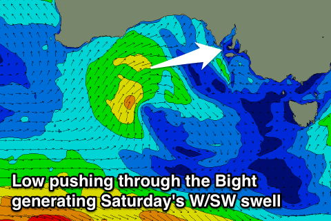
South Coast: Friday's onshore change will be linked to the remnants of the mid-latitude low forming off WA pushing east through the Bight, and we should see some fun short-range W/SW swell from this system on Saturday (best on the Mid).
Middleton isn't due to see much size with 2ft sets and 3ft+ waves at Waits and Parsons but with SW winds.
Sunday looks poor with lingering S/SE winds and a tiny fading swell from Saturday.
Later in the day however, a strong new S/SW groundswell is due to arrive, peaking through Monday. This will be generated be a strong polar frontal progression forming south-west of WA Wednesday, swinging back up towards Tassie over the coming days and into Saturday.
While a late increase should be seen Sunday, conditions will be poor with fresh S'ly winds, with a peak due Monday to 3-5ft at Middleton and 5-6ft at Waits and Parsons. Winds may be lingering from the S/SE, but we'll review this again on Wednesday.
Mid Coast: Saturday's W/SW swell should come in at a good 2ft, but with morning S/SW winds. The afternoon should become cleaner as winds tend more S/SE.
The swell should then drop from 1-1.5ft Sunday and become tiny into Monday with the S/SW swell really no impacting the Mid. More on this Wednesday.

