Great weekend, poor next week
South Australian Forecast (issued Friday 18th September)
Best Days: Saturday South Coast, Sunday morning South Coast, Tuesday and Wednesday Mid Coast
Recap
Poor conditions yesterday across the South Coast with a fresh onshore wind but plenty of size. The Mid Coast was better, persisting in the 1-1.5ft range but becoming bumpy into the afternoon.
Today conditions were better down South with a variable tending light offshore breeze and good 3-4ft of swell across Middleton with larger sets out at Waits and Parsons, on the edge of being too big. The Mid was also clean but tiny and around 0.5-1ft. Conditions have since deteriorated down South with a fresh S'ly wind.
This weekend and next week (Sep 19 – 25)
The weekend is still looking great down South, but a W'ly change has been sped up with Sunday afternoon now becoming wind affected.
But looking into tomorrow, and today's good pulse of SW groundswell will ease off slowly tomorrow, with 3ft sets at Middleton and 4-5ft waves at Waits and Parsons through the morning. The Mid should continue to offer 1ft+ sets.
Winds will be great and offshore from the N/NE with only light sea breeze due into mid-late afternoon (possibly remaining variable).
A new pulse of SW groundswell is due into Sunday from a strong pre-frontal fetch of W/NW gales pushing in from the Indian Ocean yesterday and today.
 This should keep good 2-3ft sets hitting Middleton with 4ft+ waves at Waits and Parsons and 1ft+ sets on the Mid.
Conditions will be clean but windy with a strengthening N'ly breeze, tending N/NW around midday ahead of a W/NW change through the afternoon and then W/SW around dark.
The change will be associated with a small cut-off low pushing in from the west, and this should kick up a new W/SW windswell for Monday but only to 1-2ft or so on the Mid.
The South Coast will remain poor with fresh and gusty SW winds Monday, with a new long-range W/SW groundswell due to fill in through the afternoon.
This swell while strong, generated south-west of WA the last couple of days should see Middleton kick to 3-4ft later in the day with 5-6ft sets at Waits and Parsons while the Mid should see 2ft+ sets, stronger than the local windswell but onshore.
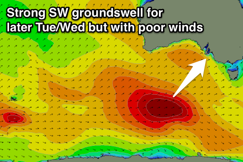
The stronger SW groundswell for Tuesday afternoon is still on track, but so are the poor onshore winds.
This groundswell is starting to be generated today by a vigorous polar low firing up in the Heard Island region, with a fetch of severe-gale to storm-force W/SW winds due to be generated through our south-west swell window as it pushes east over the weekend.
This groundswell should kick strongly Tuesday afternoon, reaching 4-5ft+ at Middleton and 6-8ft at Waits and Parsons with inconsistent 2ft sets on the Mid. Winds will be poor though and fresh to strong from the S/SE.
Wednesday doesn't look any better as the swell eases under fresh SE tending S/SE winds. The Mid will be clean though.
A strong high pressure ridge moving in from the west will take its time, with average E/SE winds due to persist Thursday, lighter into Friday and possibly E/NE.
The surf will become smaller as well with small to moderate amounts of SW groundswell from frontal activity swinging in from the Indian Ocean, but we'll have a closer look at this on Monday. Have a great weekend!

