Plenty of swell to come but with average winds
Nias, Mentawai, South Sumatra forecast by Craig Brokensha (issued Thursday 3rd September)
Best Days: Protected spots every day besides Friday when the swell's small
This week and next week (Sep 9 - 18)
A large S/SW groundswell is currently breaking across the Mentawais but conditions are best in protected spots as the relentless S/SE winds continue across the region.
We should see the swell ease through tomorrow from 6-8ft at exposed breaks during the morning, smaller into Thursday, bottoming out Friday morning. Moderate to fresh S/SE winds will persist and favour more protected breaks which will be smaller.
 Into the weekend a good and consistent S/SW groundswell is due. This is currently being generated by a strong and high riding frontal system in the central Indian Ocean, aiming a fetch of SW gales through our southern swell window.
The high riding nature and favourable projection of the system should produce a good S/SW groundswell that should show later Friday but peak through Saturday afternoon to a good 6ft+ across exposed breaks, holding a similar size through Sunday.
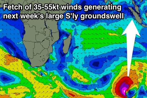
Into Monday afternoon though we'll see a much larger and more powerful S'ly groundswell pushing in, generated by a vigorous polar low projecting a captured fetch of severe-gale to storm-force S/SW winds up towards Western Australia. This system is on the edge of our southern swell window and will produce a S'ly directed groundswell that should arrive through Monday and really kick later in the day to 8ft+ across exposed breaks by dark.
A peak is due overnight, with the swell easing from a similar size Tuesday morning, further down through Wednesday and Thursday.
Unfortunately our average S/SE winds are due to worsen and become strong through Sunday and Monday limiting options to protected spots, which will be much smaller away from the S'ly swell direction. Winds should back off to the fresh range Tuesday again but persist the rest of the week.
It's worth noting that Nias to the west will see a touch less size with this S'ly groundswell and South Sumatra bigger surf around 8-10ft.
Longer term, September continues to deliver with some large inconsistent long-range S/SW groundswell due into the 21/22 but we'll have a closer look at this Thursday.
16 day Mentawai forecast graph
16 day Nias forecast graph
16 day South Sumatra forecast graph

