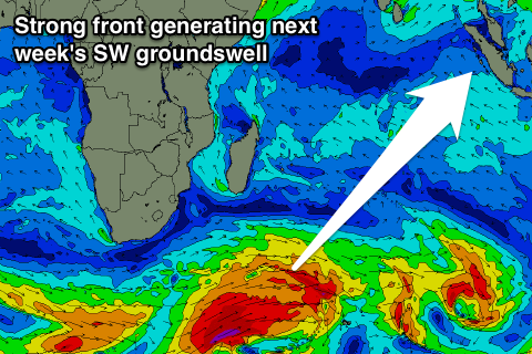
Inconsistent S/SW swells with a large S/SW groundswell for next Thursday
Nias, Mentawai, South Sumatra forecast by Craig Brokensha (issued Thursday 2nd Jul)
Best Days: Saturday afternoon, Sunday, Monday, Tuessday, later Wednesday
This week and next week (Jul 3 – Jul 10)
Less than ideal conditions the last day or so with easing amounts of swell and fresh to strong S/SE winds, limiting options.
Tomorrow will be average again with the swell continuing to ease under unfavourable and fresh S/SE winds.
Our new inconsistent S/SW groundswell for Saturday afternoon and Sunday is still on track, and winds should ease back to a light to moderate SE breeze.
Exposed spots are due to build to an infrequent 4-5ft+ (6ft sets Southern Sumatra) late Saturday and hold Sunday before easing Monday.
This trend will be halted into Tuesday with a long-range and small S/SW groundswell due, keeping exposed breaks topped up with 3-4ft+ waves before easing into Wednesday.
 As talked about last update, our large S/SW groundswell for later in the week is still on track, with a strong node of the Long Wave Trough starting to push east through the Indian Ocean.
A vigorous polar front is developing under the LWTs influence, with a fetch of severe-gale W/SW winds due to be projected up and through our southern swell window over the coming days, to be then piggy-backed by a secondary weaker system through Sunday and Monday.
A large long-period SW groundswell will result, arriving late in the day Wednesday (building to 6ft+ late), peaking Thursday to 8-10ft at exposed breaks. The swell should be a touch smaller Friday but still large and ease slowly into the weekend and early the following week.
Light to moderate SE winds are due through the swells peak at this stage, freshening as it eases into the weekend.
South Sumatra will see stronger SE winds, limiting options. More on this in Tuesday's update though.
16 day Mentawai forecast graph
16 day Nias forecast graph
16 day South Sumatra forecast graph

