Very large swell for Thursday/Friday

Nias, Mentawai, South Sumatra forecast by Craig Brokensha (issued Tue 24th Jun)
Best Days: Every day over the coming period
This week (Jun 24 - 27)
After late last week's strong pulse of SW groundswell we should of seen wave heights back off into the weekend. A new large S/SW groundswell should of arrived yesterday though and held well into this morning.
Into tomorrow a drop in size is expected out of the S/SW as winds increase a touch from the N/NW, favouring south-east corners across the region.
Of greater importance though is one of the strongest and largest swells this year across the Indonesian Archipelago (upgraded since last Thursday's update). This has been generated by a vigorous and broad polar frontal progression developing under South Africa Thursday last week, pushing east-northeast into the Southern Indian Ocean over the weekend while producing various fetches of 35-50kt+ SW winds over a large and expansive area of ocean.
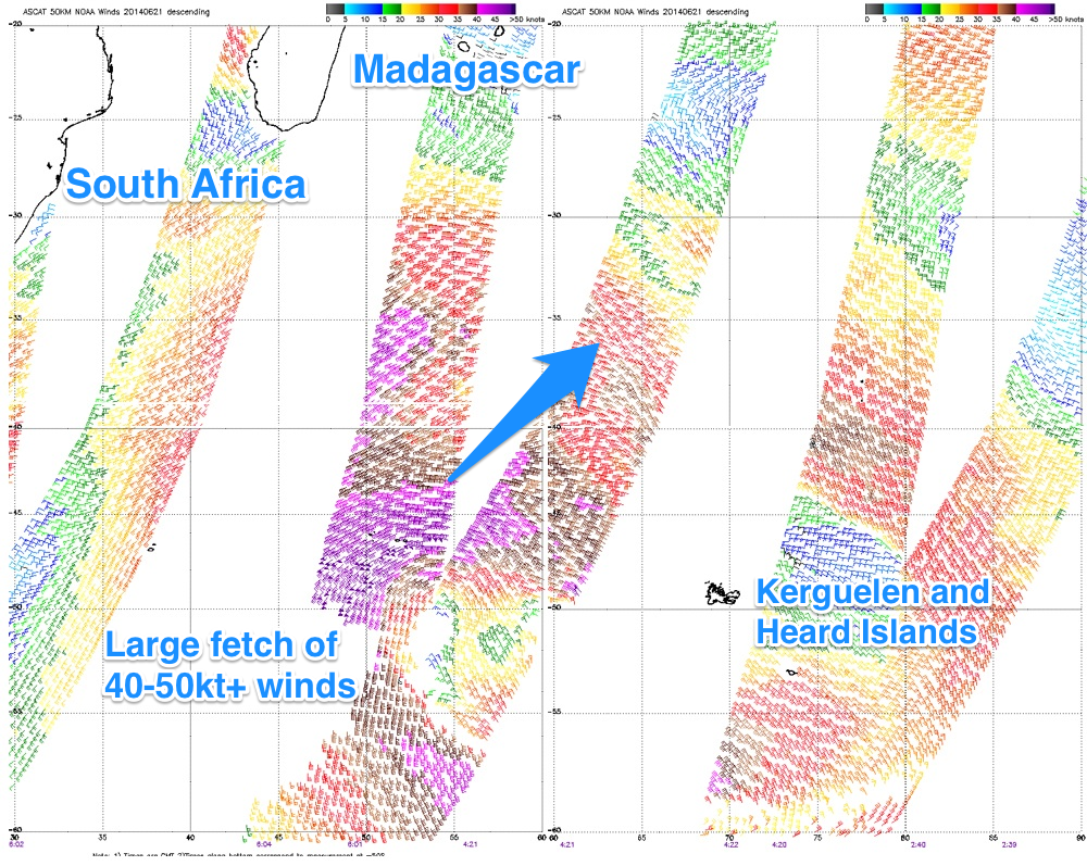 To the right I've constructed a collection of satellite images taken south-east of South Africa, showing the enormity of the weather system and peak wind speeds in the 50kt range.
The forerunners of this swell should arrive through Wednesday in the 23+ second range with a possible late noticeable kick across southern regions.
Thursday will see the swell fill in proper with exposed spots in the Ments expected to build to a large and very powerful 12ft to occasionally 15ft by dark. Nias should see a touch less size with an afternoon kick to 10-12ft with bigger sets at exposed spots.
Southern Sumatra will be huge and only protected spots will be the go.
Winds through the swell look to be generally light from the N/NW on Thursday as the swell fills in, while more variable winds are due on Friday as the swell slowly drops away.
This weekend onwards (June 28 onwards)
Saturday will still be large and only for experienced surfers but a steady drop in size is due through the weekend and further into early next week.
Longer term a medium sized plus SW groundswel is due through Tuesday with a slightly bigger SW groundswell for Friday, but we'll discuss this in more detail on Thursday.
16 day Mentawai forecast graph
16 day Nias forecast graph
16 day South Sumatra forecast graph