Ments: Lots of size, climaxing next Thursday/Friday
Nias, Mentawai, South Sumatra forecast by Craig Brokensha (issued Thu 19th Jun)
Best Days: Every day over the coming period
This week and weekend (Jun 19 - 22)
A fun pulse of swell arriving through Tuesday should of held well into yesterday ahead of a much larger and stronger pulse today.
This S/SW groundswell is expected to ease gradually over the coming days, dropping back from 6-8ft across the Ments tomorrow and further from 5-6ft Saturday before bottoming out Sunday afternoon.
Winds may have been up a little this morning but they should ease into this evening and remain generally light and variable over the coming days.
Next Monday onwards (Jun 23 onwards)
The first of two large groundswells due next week should arrive strongly through Monday ahead of a secondary pulse Tuesday. This swell is being generated by a great looking polar front that started it's life north-west of Heard Island and is projecting north-eastwards towards Bali while generating winds in the 35-40kt+ range.
The north-east projection will see Monday's initial pulse form the S/SW swing a touch more southerly into Tuesday, favouring exposed south facing breaks.
Size wise, the Ments should see 6-8ft sets both Monday and Tuesday with more size towards South Sumatra and less consistent 6ft to occasionally 8ft waves around Nias.
A drop in size is then due Wednesday ahead of a much more significant SW groundswell on Thursday and Friday.
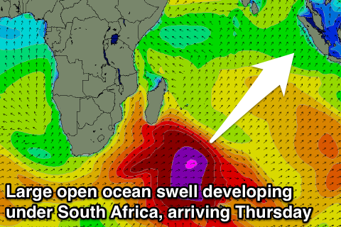
 The frontal progression generating this swell will be a monster, firing up from under South Africa and pushing into the Southern Indian Ocean. An initial and broad fetch of 35-45kt gales will setup an active sea state for an additional fetch of 35-50kt winds to move over, setting in motion a large, long-period SW groundswell.
The forerunners of this swell should arrive later Wednesday in the 22s range, but the bulk of the swell is due to fill in Thursday afternoon ahead of a peak overnight.
Size wise, the Ments should build to 10ft through the afternoon with the chance of some bigger bombs on dark, with similar sized waves up around Nias to 8-10ft while Southern Sumatra will cop the brunt with exposed spots likely to be around 12ft+.
The swell should ease from a similar if not slightly smaller size Friday and further into Saturday, Sunday and the following week.
Winds through this swell should be variable on Thursday before coming up from the SE from Friday onwards but without too much strength (moderate in Southern Sumatra).
Longer term there's nothing major on the cards with a slow period expected through the week starting the 30th of June.


Comments
"Longer term there's nothing major on the cards with a slow period expected through the week starting the 30th of June."
What a shame I fly home on the 1st July. June has been very kind indeed.
Great forecast last Thursday and Friday for North Sumatra. Some of the deepest barrels of my life.
Great to hear syril! And there's one swell now lining up through the period which should keep the punters happy.