Poor end to the week with improving surf Sunday
Victorian Forecast by Craig Brokensha (issued Wednesday November 27th)
Best Days: Today, Sunday morning Surf Coast, Tuesday morning, WednesdatyThursday next week (winds pending)
Features of the Forecast (tl;dr)
- Low point in swell tomorrow AM with variable tending fresh SE winds
- Strong E/SE-SE winds Fri with moderate levels of building SE windswell (moderate sized, building SW groundswell also in the mix)
- Winds easing a touch Sat as the SE windswell continues
- Small, fading SE windswell and background SW swell Sun with W/NW tending W/SW winds
- Small Mon AM, with a long-range, inconsistent W/SW groundswell building into the PM
- W/NW tending SE winds Mon
- Easing swell Tue with N/NE tending SE winds
- Moderate sized W/SW groundswell building next Wed, easing Thu
Recap
Light, variable winds and heavy fog set in across the Surf Coast yesterday morning, lingering around the Torquay region and further west most of the day. Our new swell arrived though kicking the Surf Coast to an easy 3ft with solid 5-6ft sets to the east as morning winds went a little sea breezy.
Today the swell is easing and light winds are creating clean conditions across all locations with easing 2-3ft waves on the Surf Coast, 3-5ft to the east. Conditions will remain favourable ahead of a late afternoon S/SW change.

Great waves in between bigger closeouts today
This week and weekend (Nov 28 - Dec 1)
We’ve unfortunately had a deterioration to the wind outlook into the end of the week, when our good, long-range W/SW groundswell is due to arrive.
A trough that’s linked to later this afternoon’s change will linger in the region tomorrow before being squeezed by an inland depression through Friday/Saturday.
This will bring freshening SE winds tomorrow afternoon ahead of stronger E/SE-SE breezes on Friday/Saturday (a touch weaker) along with moderate levels of stormy SE windswell.
This will overpower any SW groundswell seen into Friday afternoon with nowhere to really recommend.
Into Sunday we’re looking at a 180° swing in winds back to the W/NW as the low to our north drifts south. This will see rapidly easing levels of SE windswell and background SW swell from 2ft+ on the Surf Coast, bumpy and poor to the east.
Moving into next week and a lingering W/NW wind will favour the Surf Coast on Monday morning ahead of sea breezes.
Size wise the morning looks small, but through the day a very distant, long-range W/SW groundswell is due to build into the afternoon and peak overnight, with very slow 2ft to possibly 3ft sets due on the Surf Coast, 3-5ft to the east.

The source is a very distant storm that developed south-east of South Africa and is now moving through the Indian Ocean.
Tuesday could be the pick as the swell eases under a N/NE offshore but we’ll have to confirm this on Friday.
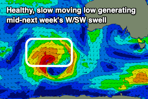
Longer term a great low forming to the south-west of Western Australia is set to produce a great, slow moving fetch of gales while moving through our western swell window. This should generate a moderate sized W/SW groundswell for Wednesday/Thursday. More on this Friday.


Comments
Hi Craig what kind of wave size are we likely to see Friday morning along the Peninsula ?
Will that SE wind swell effect the wave heights around the Island
asking for a friend
I'd expect the long-range groundswell to be 4-5ft or so and building.
Hi Craig, what do you think swell size will be down to tomorrow morning on each coast? Do you think the wind could be light enough at dawn for a desperate paddle? Thanks
... and what beach should I surf, how warm will the water be, will there be a crowd, what board should I ride, and what is my horoscope.
Very exotic weather this arvo. Glassy back beach with 20 knot NNW at South Channel. The change about halfa later. Battling each other for a while perhaps?
Surprisingly ok today, decent swell around and wind stayed very light until about 1.
Well there’s something you don’t see everyday. Swell direction 163-172 degs with a peak period of 18secs.
Ha.
17.6 deg though! Basically tropical!
https://www.greatoceanroadauthority.vic.gov.au/Latest-News/Urgent-works-...
SE swell and period will be having fun with it on high tide today
2 day to trip Torquay region with my son to start school holidays any idea over the next fortnight when will be best
what kinda answer you expecting to get here?
Has to earn his Stripes eh?!
Joking aside the latest notes are up Stripes, there's no standout days but a couple to choose from, though I would like more confidence in the winds over the coming days.