Indonesia/Maldives forecast Mar 4
Indian Ocean Basin analysis by Craig Brokensha (issued Tuesday 4th March)
This week through next (Mar 5 -14)
Our fun pulse of mid-period S/SW swell due later Friday and Saturday came in nicely, with the size easing since.
Some background mid-period S/SW swell from unfavourably aligned but healthy frontal activity to the south-west of Western Australia last week has provided a fresh boost in size today with the energy due to fade over the coming days.
We then look at the S/SW swell due later week, with a healthy but not overly strong frontal progression projecting towards Western Australia over the weekend and yesterday.
A fetch of strong to gale-force SW winds should produce a moderate + sized increase in swell Friday to 6ft+ across the magnets, easing into next week.
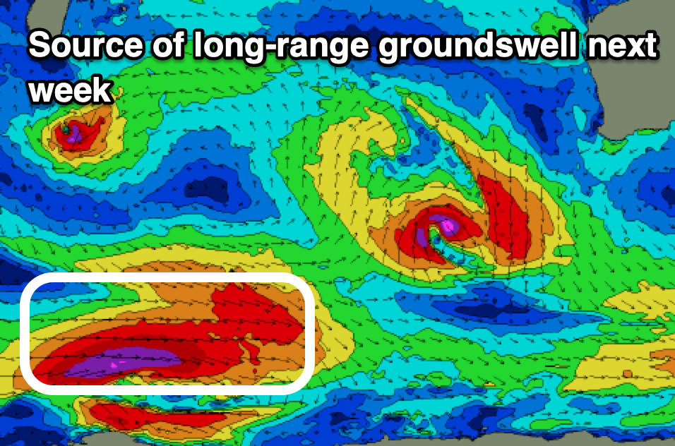
Our next increase in swell will be a moderate to large but inconsistent S/SW groundswell for next Tuesday afternoon and Wednesday morning, generated by a strong polar low firing up south of South Africa today.

A great fetch of severe-gale W’ly winds are due to push east through Wednesday and then north-east Thursday.
The swell from this low should come in at 6-8ft but we’ll review this Thursday.
Local winds through the period are favourable and variable offshore ahead of variable/weak sea breezes.
In the Mentawais, a fetch of weak but stationary W’ly winds west of the islands will generate a small to moderate sized W’ly swell later week, easing slowly over the weekend as local W-W/NW winds also start to ease later week.
----------------------------------------------
Maldives:
With small, background swell energy in the water this week, our next noticeable increase in size is due through Friday, peaking later and then easing Saturday. This was generated by the healthy storm projecting towards Western Australia over the weekend, while the secondary polar low firing up today will generate a stronger pulse of groundswell later Monday and Tuesday morning.
For the central and northern atolls, SE trade-swell looks to start building slowly through the weekend but more so next week, coming in moderate in size. This will be thanks to a great, broad fetch of E/SE trades setting up in the Indian Ocean from later this week, with the swell due all next week and into the following weekend under generally light, favourable winds. There might be a further pulse in size depending on tropical developments, but more on this Thursday.
Eastern Indonesia:
Easing S/SW swell tomorrow, further Thursday.
Moderate + sized, mid-period S/SW swell for Friday to 6ft+ across exposed breaks.
Easing surf on the weekend.
Moderate-large, inconsistent S/SW groundswell building Tuesday, reaching 6-8ft later or into Wednesday morning.
Light, local offshore winds ahead of weak if not variable sea breezes
Uluwatu 16-day Forecast Graph/WAMs
Western Indonesia/Mentawais/South Sumatra:
Building W’ly swell over the coming days reaching 4ft at its peak Friday, easing slowly on the weekend.
Moderate sized, mid-period S’ly swell for Friday to 4-5ft+ across exposed breaks.
Moderate-large, inconsistent S/SW groundswell for later Tuesday and more so Wednesday morning to 6ft across exposed breaks.
Moderate to fresh NW winds for the coming days, tending variable from Friday.
Mentawai 16-day Forecast Graph/WAMs
Maldives:
Small to moderate sized S’ly swell building to 3-4ft on the southern atolls Friday afternoon, easing Saturday.
Inconsistent S’ly groundswell for later Monday but more so Tuesday morning to 3-4ft on the southern atolls.
Building S/SE trade-swell from the weekend, stronger from the SE through next week and to 4-5ft, possibly building further.
Variable winds, increasing from the N/NE from the weekend.


Comments
Latest notes are live.
Thanks Craig , fun pulse today on NL , from flat to knee high all morning then on high tide the switch got flicked and it was overhead sets . Looking forward to Friday and next week , so good that we have the ESE air flow so early in the season . Stoked .
Thanks Supa!
I arrive thursday trusting my back holds up.
Best of luck evo , waves & weather looking good .