Indonesia/Maldives forecast Jan 30

Indian Ocean Basin analysis by Craig Brokensha (issued Thursday 30th January)
This week through next (Jan 31 - Feb 7)
A small lift in mid-period S/SW swell is due through tomorrow, easing into Saturday, replaced by a stronger, less consistent S/SW groundswell into the afternoon and Sunday.
The groundswell was produced by a strong but tight low in the Heard Island region earlier this week, with fun sized sets due across the magnets, easing into Monday next week.

Also in the mix will be some small to moderate sized mid-period W’ly swell this weekend through all of next week thanks to strengthening W/NW winds to our west, linked to an active MJO signal moving through the region.
Locally it will bring favourable winds that look light, locally offshore and variable into the afternoons, as the westerly activity sits off the coast, west-southwest of us
The W/NW winds might feed into a tropical cyclone and if this occurs, we’ll see some sizey S/SE swell developed for the Mentawai and South Sumatran regions, emanating off strengthening S/SE-SE winds forming on the south-west flank of the depression.
Coming back to eastern Indonesia and westerly swells look to continue through all of next week, while into Thursday/Friday, our larger S/SW groundswell is still on track.
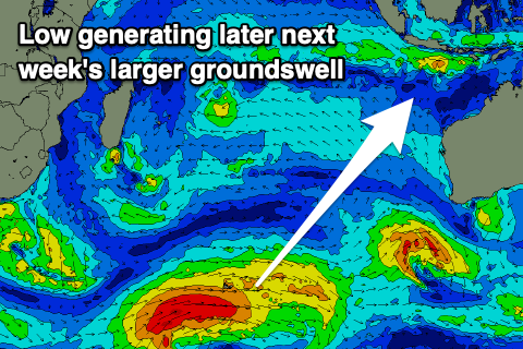
The low linked to this swell has formed south of South Africa and will project slowly east-northeast while generating a great fetch of W’ly gales (reaching severe-gale in strength for a period).
As the low moves across the Heard Island region it’s due to slowly weaken though it will maintain a fetch of strong winds before breaking down south of Western Australia early next week.
A moderate to large sized mix of mid-period and groundswell are due to build Thursday afternoon, reaching 6ft+ by dark, peaking overnight and then easing from a similar size Friday.
Winds at this stage look to strengthen locally out of the W-W/NW later next week but we’ll confirm this on Tuesday.
----------------------------------------------

Maldives: A slight lift in S/SE-SE trade-swell energy is due over the coming days, peaking through the weekend but of greater significance is the S’ly groundswell due across the southern atolls later Tuesday, peaking Wednesday morning.
The source is the strong low south of South Africa, with it forming just west enough to fall within our swell window.
Following this, the tropical developments south of Indonesia look to generate various fetches of SE winds that should produce building levels of trade-swell from later next week, more so into next weekend. Check back here next week for more details on the size and timing as its moving around a bit thanks to the uncertainty of each tropical system.
Eastern Indonesia:
Mid-period S/SW swell tomorrow to 4ft on the magnets through the day.
Small-moderate sized, inconsistent S/SW groundswell building Saturday, peaking Sunday to 4-5ft across exposed breaks, easing Monday.
Small to moderate sized W’ly swell from this Friday through next week
Moderate to large sized S/SW groundswell building to 6ft+ later Thursday, easing from a similar size Friday.
Light, variable locally offshore winds, variable into the afternoons. Winds strengthening from the W-W/NW later next week.
Uluwatu 16-day Forecast Graph/WAMs
Western Indonesia/Mentawais/South Sumatra:
Inconsistent S/SW groundswell for Saturday afternoon and Sunday to 3-4ft on the south magnets.
Building moderate sized W’ly swell this weekend and further next week, tending more SW in direction.
Moderate to large sized S/SW groundswell building to 6ft+ Thursday afternoon, easing Friday.
Slowly strengthening NW winds across southern locations from tomorrow but more so Sunday through Tuesday.
Winds slowly easing next Friday but more so next weekend.
Mentawai 16-day Forecast Graph/WAMs
Maldives:
Building S/SE-SE trade-swell from tomorrow, peaking on the weekend to an inconsistent 3ft across exposed breaks, easing next week.
Moderate sized S’ly groundswell building later Tuesday, peaking Wednesday to 4ft across the southern atolls.
SE trade-swell building later next week but more so next weekend.
Light to moderate N/NW winds tomorrow and Saturday.
Moderate to fresh NE winds across northern and central locations from Sunday, lighter N/NW to the south.
Winds tending more E/NE late week.
Comments
Latest notes are live.
Thanks Craig , it’s actually been a fun pulse the last couple days, yesterday was a real surprise with overhead sets and reasonably consistent for the swell windows we get on NL , even the wind behaved and stayed light onshore most of the day. Rain came back with a vengeance this morning, just isolated scuds now . Probably head over for some east coast action next week .
Nice, I didn't have any major trends for the background pulses, tomorrow hopefully a touch stronger.