Indonesia/Maldives forecast Jan 28

Indian Ocean Basin analysis by Craig Brokensha (issued Tuesday 28th January)
This week through next (Jan 29 - Feb 7)
A fun pulse of inconsistent groundswell should have been seen into Sunday afternoon and Monday morning, with it easing back through today, with smaller levels of background S/SW energy due over the coming days.

A monsoonal surge later week through next will bring strengthening W/NW winds to our west, though inshore they still look favourable and lighter NW through the mornings. The afternoons from the weekend into next week look decent as well with favourable variable winds expected.
This surge will generate some small, weak W’ly swell from Friday through next week, possibly persisting into next weekend and beyond.
This will contaminate exposed locations a little and especially with no overly significant swells for the coming week and a bit, be the dominant energy in some spots.
Otherwise, a small to moderate sized, inconsistent S/SW groundswell is due to build Saturday afternoon, peaking through Sunday. The source was a small, compact low forming in the Heard Island region, with a fetch of W/SW gales producing a fun but smaller swell than seen Sunday/Monday.
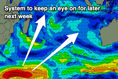
Following this a better, moderate to large sized S/SW groundswell is due later week thanks to a broader, more sustained polar storm but we’ll review this on Thursday.
In the Mentawais the swell sources look minimal besides building W’ly swell from the strengthening W/NW winds west of us from the weekend through next week. It looks to get moderate in size but with local N/NW-NW winds that will be strong across southern locations, lighter to the north.
Otherwise the better S/SW groundswell for later next week is worth keeping an eye on.
----------------------------------------------
Maldives: The inconsistent SE groundswell from the weekend has been backed up by inconsistent, small levels of SE trade-swell with this due to ease back over the coming days.
Some new more consistent S/SE-SE trade-swell is due to back it up from late week and more so into the weekend owing to a burst of E/SE-SE trades off Western Australia, reaching west to a position south of us.
The swell looks to peak through the weekend before easing next week owing to the trade fetch breaking down.
Otherwise the storm discussed for late next week across Indonesia should also generate some moderate sized S’ly groundswell for our region during the middle to end of the week, but again more on this Thursday.
Eastern Indonesia:
Easing surf over the coming days.
Small levels of background S/SW swell next week, strongest Friday and to 4ft on the magnets through the day.
Small-moderate sized, inconsistent S/SW groundswell building Saturday, peaking Sunday to 4-5ft across exposed breaks, easing Monday.
Small W’ly swell from this Friday through next week.
Moderate to large sized S/SW groundswell on the cards for later next week to 6ft+.
Light morning NW-W/NW winds ahead of sea breezes, fresher W/SW on Thursday and more variable from Friday.
Uluwatu 16-day Forecast Graph/WAMs
Western Indonesia/Mentawais/South Sumatra:
Small background S/SW swell this week.
Inconsistent S/SW groundswell for Saturday afternoon and Sunday to 3-4ft on the south magnets.
Building moderate sized W’ly swell across southern locations next week.
Moderate to large sized S/SW groundswell on the cards for later next week to 6ft+.
Strengthening NW winds across southern locations from later week, weaker to the north. Easing winds next week.
Mentawai 16-day Forecast Graph/WAMs
Maldives:
Easing SE trade-swell from 2-3ft over the coming days.
Building S/SE-SE trade-swell from Friday, peaking on the weekend to an inconsistent 3ft across exposed breaks, easing next week.
Moderate sized S’ly groundswell building next Wednesday, peaking Thursday to 4ft across the southern atolls.
Fresh E/NE winds across northern locations, weaker NW to the south tomorrow, weaker NE to the north on Thursday and more variable N on Friday.
Weaker N-N/NE winds on Saturday, freshening from the E/NE across northern locations from Sunday.
Comments
Latest notes are live.
Thank you Craig , not much to get excited about but a few days amongst it . I can’t be bothered hunting the magnets in Bali , apparently every surf school plus 1 goes to serangan these days. Talking to an expat that took his wife and dinghy over there , as soon as he hit the beach security guards came down and told him he wasn’t allowed there . Don’t know what the go will be once it’s open to the public again with shopping centres and kura kura village . Few years off yet .
My back is finally starting to heel may try the swell end of next week.
Just looked at the surf size forcast I think I will reconsider with only
one day of 6ft.
Hey Craig, in these forecasts when you refer to the southern atolls in the Maldives, do you mean the south Male atolls or down Huvadhoo Atoll way?
Down Huvadhoo Atoll way.
Thanks Craig, might treat myself a trip to Ayada Maldives last two weeks of April this year