Indonesia/Maldives forecast Oct 22
Indian Ocean Basin analysis by Craig Brokensha (issued Tuesday 22nd October)
This week through next (Oct 23 - Nov 1)
Our mix of mid-period S/SW energy and long-range SW groundswell should be in the water today following an increase in size yesterday afternoon.
The models are over-forecasting the size and we can expect both swells to ease back slowly through the week thanks to trailing, swell generating frontal systems behind the main storms, providing plenty of fun waves across the magnets.
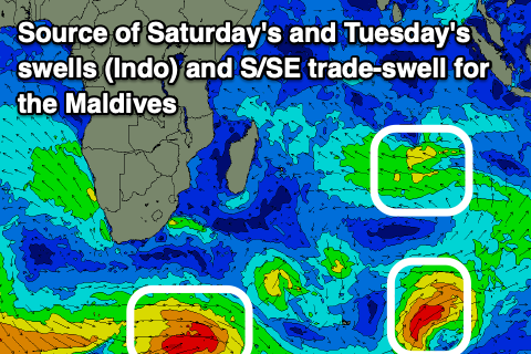
As touched on last Thursday, the next noticeable increase in size is due later Friday but more so on Saturday, generated by a small but healthy low that formed around the Heard Island region on the weekend. An initial fetch of gales have since weakened while projecting towards Western Australia, with the swell due to come in fairly south.
It’s due to show on dark Friday but likely peak Saturday morning, moderate in size before easing Sunday and Monday.
Into late Monday but more so Tuesday another long-range SW groundswell is due, followed by a secondary better pulse later Thursday/Friday - similar to the one currently in the water but with less size.
The first swell was generated by a short-lived burst of gales to the south-east of South Africa and is being over-forecast, with the secondary pulse later next week being generated by a polar low to the south-east of South Africa.

Fetches of severe-gale W/NW tending W winds are due to generate a moderate sized swell, peaking through Thursday afternoon/evening.
Beyond this there’s nothing significant on the cards at all so make the most of the current and coming swells.
One final point on the local winds and it looks like the transition between the winter trades and incoming monsoon is happening with the trades disappearing, replaced by more southerly to south-westerly flow (variable offshore each morning).
----------------------------------------------
Maldives: Following a fun weekend of S’ly groundswell and SE trade-swell, we’re now seeing an easing trend across the region.
A re-intensification of SE trades in our southern swell window yesterday and today should produce some new S/SE trade-energy for Thursday/Friday (moderate in size) before easing through the weekend.
A weaker background SE fetch should provide small levels of swell from the weekend through next week but to no major size.
Otherwise the activity to the south-east of South Africa should generate S’ly groundswell pulses from Sunday through next week, with the best due on later Monday/Tuesday.
Winds look to shift from the W to SW this week and then more S/SW into the weekend while freshening before reverting back to the W/SW next week.
Eastern Indonesia:
Moderate + sized, inconsistent SW groundswell and mid-period S/SW to 6ft across exposed breaks today, easing slowly Wednesday/Thursday.
Smaller, reinforcing mid-period S/SW swell later Friday and Saturday morning to 4-5ft across exposed breaks, easing Sunday.
Small, inconsistent SW groundswell for later Monday, peaking Tuesday to the 4ft range across exposed breaks.
Slightly better, inconsistent SW groundswell arriving later Wednesday, building Thursday, reaching 4-5ft across exposed breaks, easing Friday.
S-S/SW winds over the coming period, variable offshore each morning. Possible small trade flurry Wednesday/Thursday next week.
Uluwatu 16-day Forecast Graph/WAMs
Western Indonesia/Mentawais/South Sumatra:
Easing S/SW groundswell from 6ft across exposed breaks this morning.
Small-moderate sized S’ly swell for later Friday but more so Saturday morning to 4ft across exposed breaks.
Small, inconsistent S/SW groundswell for later Monday, peaking Tuesday to the 4ft+ range across exposed breaks.
Slightly better, inconsistent SW groundswell building Wednesday, reaching 4-5ft across exposed breaks, easing later week.
Variable winds, tending N/NW-NW across the north later this week. Winds tending S/SE-SE across southern locations next week.
Mentawai 16-day Forecast Graph/WAMs
Maldives:
Easing mix of S and SE swells tomorrow.
New, moderate sized S/SE trade-swell Thursday/Friday to 4ft (smaller Male), easing into the weekend.
Small S’ly groundswell Sunday to 3ft across the southern atolls, with a secondary better pulse for Monday afternoon/Tuesday to 4ft+.
Moderate W tending SW winds over the coming days, fresher S/SW on the weekend and then back W/SW next week.


Comments
Latest notes are live.