Indonesia/Maldives forecast July 25th
Indian Ocean Basin analysis by Craig Brokensha (issued Tuesday 25th July)
This week through next week (Jul 26 – Aug 4)
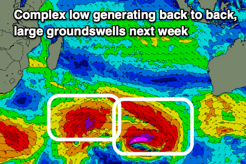
We've got a low point in swell this morning, but later today, some new long-period SW groundswell is due to arrive, peaking tomorrow, ahead of a secondary pulse through late tomorrow, peaking Thursday.

These large groundswells were generated by a broad, complex low moving across the Heard Island region since last weekend, with various fetches of severe-gale to at times storm-force W/NW-W winds generated a little off axis to Indonesia's swell window, followed by a better aligned fetch of W/SW gales.
The swells have come in large and strong across Western Australia, with large surf due in Indonesia over the coming days, easing into the end of the week and further on the weekend.
Besides a small to moderate sized lift in background SW swell energy Sunday afternoon, easing Monday, we then look to the next episode of decent swell and that looks to arrive from the S/SW next Tuesday ahead of a peak on Wednesday.
This will be generated by a healthy but not overly significant Southern Ocean frntal progression firing up from under south Africa, pushing east across the Heard Island region and then onwards up towards Western Australia.

With a persistent fetch of gale to at times severe-gale winds, we'll see an inconsistent but large S/SW groundswell developing, while a secondary front on the tail of the progression, south west of Western Australia will produce some reinforcing mid-period S/SW swell, softening the easing trend.
The models are incorrectly combining swells into later Tuesday and Wednesday so over-forecasting the size.
Coming back to the Maldives, and we should be seeing the S'ly groundswell from the complex low peaking through this afternoon, easing back slowly tomorrow.
Moderate + sized levels of SE trade-swell are due to ebb and pulse all week thanks to a broad, elongated fetch of strong E/SE winds persisting through the Indian Ocean, pulsing westward at times which will produce embedded pulses of size.

One of these is due tomorrow, ahead of another Thursday afternoon and Friday/Saturday, easing slowly into next week
The S'ly groundswell from the storm under South Africa is due into next Tuesday, coming in in the moderate to large size range.
Eastern Indonesia:
Large SW groundswell showing late today, peaking tomorrow to 6-8ft.
Larger pulse for later tomorrow, peaking Thursday morning to 8ft+ across exposed breaks, easing into the weekend.
Small to moderate sized, background S/SW swell for Sunday afternoon and Monday, easing Tuesday.
Inconsistent, moderate to large S/SW groundswell arriving later Tuesday, peaking Wednesday to 6-8ft across exposed breaks, easing slowly into the end of the week.
Moderate to fresh SE trades this week and next week, lighter and more variable each morning.
Uluwatu 16-day Forecast Graph/WAMs
Western Indonesia/Mentawais/South Sumatra:
Inconsistent SW groundswell building today, reaching 6ft late with a larger S/SW groundswell tomorrow, peaking into the afternoon to 8ft across exposed breaks. Easing swell through the end of the week and weekend.
Mod-large, inconsistent S/SW groundswell for next Wednesday/Thursday to 6ft.
Fresh to strong SE-S/SE winds this period across southern/eastern locations, weaker in northern locations, though freshening from Sunday through Monday here, becoming lighter again on Tuesday.
Mentawai 16-day Forecast Graph/WAMs
Maldives:
Inconsistent moderate to large sized S'ly groundswell peaking this afternoon to 4-6ft across the southern atolls (smaller Male), easing slowly from tomorrow.
Moderate sized + pulses of SE trade-swell between 4-6ft all week and Saturday (smaller Male), easing slowly from this weekend.
Moderate to large sized S'ly groundswell for next Tuesday, coming in at 4-5ft across the southern atolls (smaller Male).
Strengthening SE winds across southern locations today with S/SW-SW winds to the north, variable W'ly over the coming days while remaining fresh SE to the south.
Moderate W/SW winds to the north and SE to the south on the weekend, similar next week.


Comments
Latest update is live.