XXL swell on target for tomorrow

Hawaii North Shore forecast by Craig Brokensha (issued Thursday 25th February)
Best Days: Experienced surfers later tomorrow, Friday, Saturday morning, Sunday morning, Tuesday, Wednesday
This week and next (Feb 26 – Mar 4)
Monday's monster groundswell was the biggest ever recorded since 1986, some 30 years ago. However, there weren't any surfable options though across the North Shore with the raw oversized sea state, onshore winds and mix of swell trains.
 A rapid drop was seen back through Tuesday as expected from the 20ft range with much cleaner conditions.
This morning the swell has continued to ease from the 8ft range with perfect conditions.
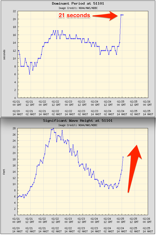
The long-period fore-runners due to arrive this evening across the North Shore hit the 51101 buoy at 12:50pm, about 10 hours travel time from Oahu. This is a touch later than forecast, but the swell has also taken a sharp J-curve upwards indicating that the surf should jump considerably overnight for tomorrow.
The source of this XXL swell was a broad and expansive fetch of severe-gale to storm-force winds developing south-east of the Kamchatka Peninsula, projecting slowly south-east (at the same speed as the swell it was producing) towards us the last couple of days.
The storm generating the swell is now weakening to our north-northwest, doing most of its production already.
There's no real change to tomorrow's size, with the North Shore due to see large 25-30ft waves, with larger sets at deep water offshore reefs.
The swell should hold for most of the day, easing late and then further down from a still XL 20ft+ Friday morning.
Conditions are the only issue tomorrow with a fresh and gusty NE tending E/NE breeze expected, not ideal.
Friday will be much better with moderate offshore winds and weak afternoon sea breezes.
Saturday will see the swell bottom out, easing from a clean fun 8ft+ or so.
As talked about on Tuesday, a new large N/NW groundswell is due Sunday from a favourably tracking and strengthening frontal system down towards us through the end of the week.
A fetch of NW gales will be produced, but at a distance from the islands resulting in a less consistent N/NW groundswell for Sunday to the 10ft range, easing into the afternoon and further Monday morning.
Following this progression a stronger, better aligned and further south projecting front should generate an XL N/NW groundswell for Tuesday and Wednesday next week which at this stage looks to come in around the 15-20ft range. Winds are dicey though with fresh to strong N/NE breezes Tuesday, better as the swell eases Wednesday.
Longer term another XXL swell swell is on the cards for late week, but we'll have another look at this Tuesday.