Weaker windswells ahead

Eastern Tasmanian forecast by Craig Brokensha (issued Friday January 24th)
Best Days: Tuesday morning, Friday morning
Features of the Forecast (tl;dr)
- Tiny weekend
- Building N/NE windswell Mon with strengthening N/NE winds, N/NW early
- Easing windswell Tue with S/SW tending fresh E/SE winds
- Fading N/NE windswell Wed with S/SW tending E winds
- Building N/NE windswell Thu with strengthening N/NE winds, easing Fri
Recap
Yesterday provided a fun mix of easing east and new south energy with light winds most of the day, similar this morning and slower, but some new east energy looks to be in the water this afternoon to 2ft.
This weekend and next week (Jan 25 - 31)
The mix of east and south swell seen at the end of this week will back off into the weekend leaving tiny waves with offshore winds tomorrow.
A trough pushing up past the coast Sunday doesn’t look to bring anything else besides some local S/SE windswell along with poor winds.
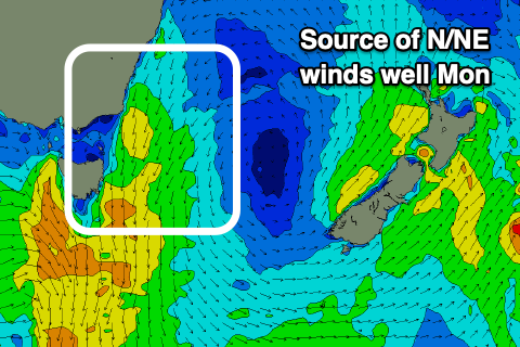
Moving into Monday, strengthening N/NE winds ahead of a deepening low moving in from the west should kick up some building N/NE windswell to 2-3ft across north-east magnets through the day.
The timing of a S/SW change looks to be early Tuesday and this will cut off the infeed of swell generating winds, bringing with it a decrease in N/NE swell from 2ft to possibly 3ft, down to 1-2ft on Wednesday thanks to a longer lived fetch of N/NE winds off the southern NSW coast.
Following this another small episode of N/NE windswell is expected later week so all in all it’s not especially active. More on this Monday. Have a great weekend!