North followed by south
Eastern Tasmanian Surf Forecast by Craig Brokensha (issued Friday June 28th)
Best Days: Late tomorrow open beaches, Monday morning, Tuesday morning, Wednesday morning
Features of the Forecast (tl;dr)
- Small N/NE windswell tomorrow, easing later with strong N/NW winds, easing later and shifting more offshore
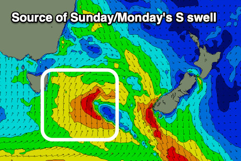
- Building S swell Sun, peaking overnight, easing Mon
- Strong SW tending S/SW winds Sun, W/SW-SW tending S/SE Mon
- Moderate sized S swell Tue, easing Wed
- W/NW tending SE winds Tue, W/sW-SW tending SE Wed
Recap
A small NE windswell faded through yesterday, tiny today.
This weekend and next week (Jun 29 - Jul 5)
The weekend is quite dynamic with strengthening N’ly winds down the coast this evening and tomorrow morning (thanks to an approaching, deepening mid-latitude low) due to kick up some small N/NE windswell to 2-3ft across selected magnets tomorrow, easing later as winds strengthen
from the N/NW, easing ahead of a late W/SW change across southern regions, lighter NW to the north.
We’ll then see strong SW tending S/SW winds into Sunday as the backside of the low moves up the coast, kicking up an afternoon increase in mid-period S’ly swell that looks to reach 3-4ft later, easing from a similar size Monday morning.

Winds should back off and swing W/SW-SW on Monday morning creating fairly decent conditions, S/SE into the afternoon.
Into Tuesday and Wednesday we should see some fun reinforcing mid-period S/SW swell thanks to healthy polar frontal activity following the low on the weekend.
This should produce 3ft+ waves across the south magnets Tuesday, easing Wednesday and with W/NW tending S/SE-SE winds on the former, W/SW tending S/SE on the latter.
The surf looks to fade into the end of the week so try and work the coming S’ly swells. Have a great weekend!

