Large, dynamic swell inbound
Eastern Tasmanian Surf Forecast by Craig Brokensha (issued Friday May 31st)
Best Days: Moday afternoon, Tuesday, Wednesday morning
Features of the Forecast (tl;dr)
- Rapid increase in large E/NE tending E swell Mon, peaking later with strong S winds, tending S/SW later
- Rapid drop in E/SE swell Tue with strong S/SW-SW winds, more W to the north
- Smaller background E/NE swell for Wed/Thu with strong S/SW-SW winds Wed, S/SW tending S/SE Thu
- Moderate sized S swell for Thu
Recap
Nothing to report in the region.
This weekend and next week (Jun 1 - 7)
The weekend looks to remain a no go for surf, with the South Arm performing better, but looking into next week, we’ve got quite a dynamic outlook of large, pumping surf.
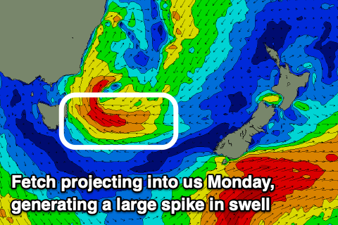
A broad low pressure system is forecast to form off the southern NSW coast this weekend, with it drifting south towards us through Sunday and Monday.

As it does so it’ll strengthen and project a fetch of strong to gale-force E/SE winds down through our eastern swell window Sunday and early Monday.
Locally, winds will strengthen from the S/SE on Sunday and then be even stronger from the S on Monday, shifting S/SW later as the low centre drifts south-west.
This will be with a large, rapidly building swell on Monday, kicking to 10ft or so through the day.
With the centre drifting south-west, the swell generating fetch will move out of our swell window during Monday afternoon and evening, resulting in a rapid drop in energy from the E/SE Tuesday from 6ft+ along with strong S/SW-SW winds across southern regions, more W/SW-W to the north.
Both later Monday and Tuesday look the days to surf, with the swell all but gone by Wednesday apart from smaller E/NE swell energy filling in from the eastern flank of the low near New Zealand.
Some follow up south swell is likely Thursday, but we’ll take a closer look at this on Monday. Have a great weekend!

