Slow period, south swell next weekend
Eastern Tasmanian Surf Forecast by Craig Brokensha (issued Friday August 26th)
Best Days: No good days, try the South Arm
Features of the Forecast (tl;dr)
- Small to tiny, weak N/NE windswell building Sun PM, holding Mon, a touch stronger Tue AM, then easing
- N/NW tending fresher N/NE winds Sun and Mon, with strong S/SW Wwinds Tue
- Likely moderate sized S'ly swell and SW to SE winds next weekend
Recap
A very weak pulse of S'ly swell yesterday with a change, easing today with clean conditions but no size.
This weekend and next week (Aug 27 – Sep 2)
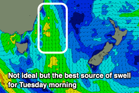
As Steve touched on during the week, the coming outlook isn't great at all with the only real source of swell being a weak infeed of NE winds through Sunday as a cold front approaching from the west squeezed a high in the Tasman Sea.
 Strengthening NE winds are due to be aimed through our swell window Sunday, weakening and retracting to the east temporarily Monday before re-strengthening into the evening ahead of the front proper.
Size wise we're not likely to see anything over 1-2ft later Sunday through Monday and with N/NW tending fresh N/NE winds both days.
Tuesday morning may see a touch more consistency to the 2ft sets before easing into the afternoon and strong S/SW winds will favour southern corners for the desperate.
Following this there's nothing else due for the week, but a strong cold outbreak into the end of next week should bring a flush of new S'ly swell energy for next weekend. With SW to SE winds.
We'll have a closer look at this on Monday. Have a great weekend!

