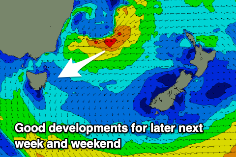
Focus on later next week onwards
Eastern Tasmanian Surf Forecast by Craig Brokensha (issued Friday 30th April)
Best Days: No good days until late next week
Features of the Forecast (tl;dr)
- Tiny N/NE windswell for Sun
- Weak S windswell for Mon PM, easing Tue
- Building moderate sized E/NE swell Fri, holding all next weekend, easing Sat with favourable winds at this stage
Recap
Tiny unsurfable waves yesterday and today.
This weekend and next week (May 1 - 7)
Our N/NE windswell for the weekend has been downgraded further and we’re not likely to see much over 1-1.5ft max on Sunday now as the swell generating fetch stays to far away from our coast.
A trough moving up the coast Saturday doesn’t look to generate any meaningful swell with a windy increase in size to 2-3ft due late in the day, fading from 1-2ft on Tuesday.
 Of greater importance is what’s expected to happen with this trough off the southern NSW coast during next week.
We’re expected to see a low form in the trough as a high slides in from the west, cradling the low.
This should see a strengthening fetch of strong to near gale-force E/NE winds feeding into the eastern side of the low, persisting from Wednesday through Saturday next week as the low stalls and drifts slowly towards New Zealand.
We should see a prolonged and moderate to possibly large sized E/NE swell event developing from Friday next week through the weekend and into early the following week.
Size wise we’re looking at easy 4ft surf, possibly peaking around 5-6ft and with favourable winds as long as the low stays east. We’ll have to confirm all this again next week, but there’s plenty of potential from late next week onwards.

