Good Friday, potential next week
Eastern Tasmania Surf Forecast by Craig Brokensha (issued Monday 8th February)
Best Days: Friday, Saturday morning, mid-late next week
Features of the Forecast (tl;dr)
- Good E/SE groundswell Fri, easing Sat with strong N/NW tending fresh NW winds
- N/NE windswell in the mix Fri, easing through the day
- Building E swell next week, possibly strong late week
Recap
Average surf yesterday, cleaner today but only small and for the desperate.
This week and weekend (Feb 2 - 7)
Tomorrow will be a lay day ahead of our E/SE groundswell and N/NE windswell combo on Friday.
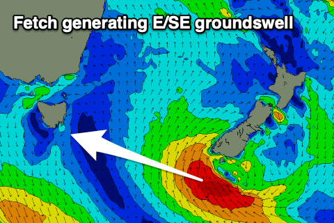
The former is being generated today by a strong low that's formed off the southern tip of New Zealand's South Island. A fetch of SE gales will be generated through our swell window, though quickly weakening, resulting in a one day wonder of sorts.
 The swell should fill in Friday and peak to a good 3-4ft across open beaches during the day, but there'll also be a N/NE windswell in the mix.
The source of the windswell will be a mid-latitude front pushing east towards us, and the fetch forming off our coast now looks to be a touch patchy when strongest early Friday morning.
This looks to put a cap on the size with sets to 3ft across the north-east swell magnets Friday morning, fading through the day.
Locally, winds will improve through the day but northern corners will be cleanest with a strong, dawn N/NW breeze, shifting NW soon after and backing off to fresh.
Saturday looks best in the morning with a W'ly offshore ahead of a SE change and easing E/SE groundswell from 2ft or so.
 Looking at the longer term outlook and we've now got some interesting developments on the cards for next week.
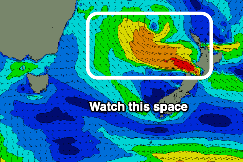
A strong high is expected to move across the southern Tasman Sea early next week as a low forming off the North Island of New Zealand squeezes it, directing strong SE winds on the edge of our swell window, swinging more E/SE and reaching gale-force after exiting Cook Strait.
This should produce small, building levels of E'ly swell from Tuesday, with a stronger groundswell for late week. More on this in the coming updates though.

