Swells from the east to north-east
Eastern Tasmania Surf Forecast by Craig Brokensha (issued Wednesday 27th January)
Best Days: Northern corners later Friday, Saturday, early Sunday southern corners for the keen
Features of the Forecast (tl;dr)
- Easing S windswell tomorrow with SE tending E/NE winds
- Building NE swell Fri with strong E/NE tending NE winds, peaking Sat AM with N/NW tending S/SE winds
- E/NE groundswell late next week from tropical activity
Recap
A tiny start to yesterday but some fun N/NE swell kicked through the afternoon as winds varied through the day, linked to a couple of troughs pushing north. This morning we've got a small, leftover 1-2ft wave on the coast.
This week and next (Jan 28 – Feb 5)
Today's S'ly change should see the surf building to the 3ft range across south facing beaches this afternoon, though with the onshore breeze.
 This swell is due to ease back tomorrow from 2ft+ or so, tiny at remaining locations, though fresh SE tending E'ly winds will create poor conditions.
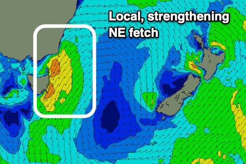
This onshore flow will be linked to the surface trough bringing today's S'ly change drifting north, then feeding into a deepening low to our west. The low is then due to drift east through the end of the week, squeezing a strong high moving under the state resulting in strengthening NE winds through our swell window Friday.
These winds will reach just below gale-force in strength, but the persistent nature through all of Friday and early Saturday will kick up a moderate-large NE swell.
Size wise, Friday should start around 2ft early, but build steadily, kicking to 4-5ft by dark, with a peak due Saturday morning to 4-6ft. Winds will be strong from the E/NE tending NE Friday, so try northern corners late in the day, but come Saturday the low is due to move east, bringing N/NW tending S/SE winds into the late afternoon.
 As winds shift S/SE though this will cut off the swell source, resulting in a drop in size, with Sunday coming in much smaller, fading from 2ft to possibly 3ft with fresh S/SE winds.
Looking beyond into next week, and there's plenty of swell potential with the tropical activity north of New Zealand still on the cards (arriving late week), and another possible inland surface trough deepening closer to us. More on this Friday though.

