Dicey period with flukey windows of OK surf
Eastern Tasmania Surf Forecast by Craig Brokensha (issued Friday 4th October)
Best Days: South swell magnets later tomorrow, late Sunday
Recap
A small, fun S'ly swell yesterday, dropping back overnight and tiny today.
This weekend and next week (Oct 5 - 11)
We've got a small pulse of S'ly swell on the cards for tomorrow, from a cold front clipping the south-east corner of the state today.
2-3ft sets should be seen across south swell magnets but winds are still looking average, S/SW-SW early and then E/SE ahead of N/NE afternoon breezes. Therefore a look across south swell magnets later tomorrow might be the go.
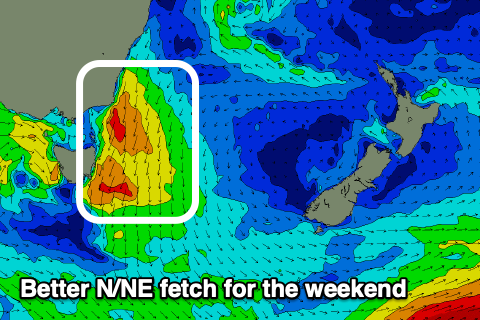
 There was a downgrade in the N/NE windswell event on Wednesday for Sunday, but we've now got a slight upgrade with the fetch of N/NE winds developing briefly in our northern swell window now looking a bit stronger Sunday morning.
With the peak in wind strength being mid-late morning, the swell is due to build Sunday and peak through the afternoon with sets to 2-3ft across north-east swell magnets but with fresh to strong N/NE winds, only shifting N/NW later in the day. Try the late session for a wave.
Come Monday morning there isn't expected to be much left in the tank with fading 1-2ft sets under a S/SW tending E and then NE breeze. Try southern corners early.
Longer term, a trough moving across us early next week is due to form into a low next week and then possibly drift south-east towards New Zealand's South Island.
This would see a good fetch of SE winds aimed through our swell window later next week, generating a fun E/SE swell for next weekend, but we'll have to have a closer look at this on Monday. Have a great weekend.

