Slight upgrade in the weekend's outlook
Eastern Tasmania Surf Forecast by Craig Brokensha (issued Friday 1st February)
Best Days: Sunday keen surfers, cleaning up late, Thursday morning, Wednesday south magnets
Recap
A small increase in N/NE windswell to 1-2ft as expected yesterday morning, but a very unexpected and larger kick to 4ft was reported through the day. This is a real surprise considering how far away the fetch was from us and seeing how closer systems don't deliver any size like this.
In any case this morning it was back to the expected fading 1-1.5ft of tiny NE swell.
Today’s Forecaster Notes are brought to you by Rip Curl
This weekend and next week (Feb 2 - 8)
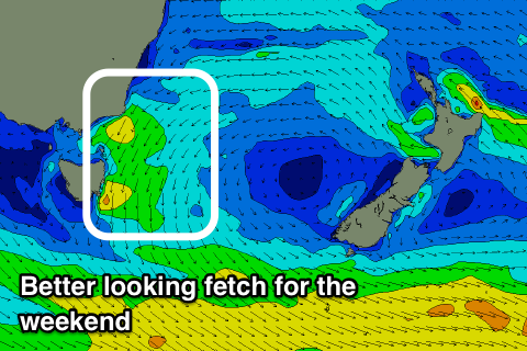
Over the weekend we'll see some new N/NE windswell building across the coast, with the fetch generating this now looking a little better than it did on Wednesday.
 A good and broad fetch of strong N/NE winds will develop off our coast tomorrow, strengthening into the afternoon and evening before slowly weakening and moving away Sunday.
This will generate a fun building N/NE windswell tomorrow, reaching 2ft+ by late in the day but with average N/NE winds, peaking Sunday morning to 3ft across north-east magnets, easing during the day.
Winds will be average and out of the N through the morning again, N/NW later in the afternoon ahead of a S'ly change on dark.
Monday then looks poor with fading 1-1.5ft waves with a gusty S/SE breeze.
Another ridge moving in quickly from the west will see a fetch of E/NE winds aimed in our swell window mid-week, generating a small E/NE swell for Wednesday afternoon/Thursday but only to 2ft or so.
Also in the mix should be an inconsistent S/SE groundswell from a polar fetch of severe-gales, similar to what we saw last weekend. This swell looks a touch smaller though and only to 2-3ft Wednesday, but we'll confirm this Monday.
Besides this there's nothing significant so try and get a wave in Sunday despite the surface conditions. Have a great weekend!

