Small NE windswell fading over the weekend, fun S swell pulse Tuesday
Eastern Tasmania Surf Forecast by Craig Brokensha (issued Friday 23rd March)
Best Days: Saturday, Tuesday at south magnets
Recap
Small to moderate amounts of messy E-E/NE swell the last two days from a strong sustained fetch of E/SE winds through the Tasman Sea. Conditions have been poor though with no real decent surfing options.
Today’s Forecaster Notes are brought to you by Rip Curl
This weekend and next week (Mar 24 - 30)
The fetch through the Tasman Sea responsible for our current swell has since weakened, and now also the NE fetch due through this evening and tomorrow off our coast is looking a bit weaker than forecast on Wednesday.
We should still see fun amounts of NE windswell tomorrow to 2ft to sometimes 3ft across north-east magnets.
 Conditions are looking to improve through the day with a N/NW-NW breeze due most of the day.
The secondary fetch developing Sunday looks more north in alignment and not as favourable and as a result expect smaller 1-2ft max.
Early light winds may tend N/NE before shifting gusty W/NW into the afternoon.
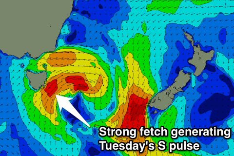
Come Monday there isn't expected to be any swell left on the coast, but a strong mid-latitude low pushing across us during the evening is expected to project a quick fetch of strong to gale-force S/SW winds up past us.
This should kick up a pulse of S'ly swell Tuesday to 3ft across south magnets through the day along with a W/SW tending variable breeze.
The swell will fade quickly overnight Tuesday with easing 1-2ft sets max on Wednesday but with offshore NW winds.
Longer term into the Easter Long Weekend we're looking at some fun E/NE swell as a tropical low forms in the Coral Sea, aiming a fetch of persistent E/NE winds towards us next week.
The specifics around this are still up for grabs so check back Monday for more on this. Have a great weekend!

