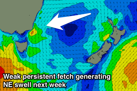
Small S pulse Sunday, NE swell mid-next week
Eastern Tasmania Surf Forecast by Craig Brokensha (issued Friday 13th October)
Best Days:
Recap
A good fun NE windswell yesterday with decent sets at north-east swell magnets, fading back through the day and further this morning leaving tiny waves out on the coast.
This weekend and next week (Oct 14 - 20)
Tomorrow will likely remain tiny across the coast with a S'ly swell showing on the charts being too west in nature to impact us.
Our better pulse for Sunday morning is still looking fun, with a good polar fetch of W/SW gales being generated through our southern swell window today.
 We should see 2ft sets at south magnets Sunday morning, fading through the day under W/NW tending NE winds.
Moving into next week we'll see a summeresque pattern setting up through the Tasman and Coral Seas, with a slow moving high being squeezed by a deepening surface trough off the SE Qld coast.
As the high starts moving slowly east around Tuesday we'll see N/NE winds feeding down the western flank of the high through our swell window, strengthening a little as mid-latitude storms try to move in from the west.
This setup looks to persist through until Thursday, with small levels of N/NE windswell due from Tuesday afternoon through Wednesday, peaking later in the day and easing from Thursday.
At this stage we're only looking at small 2-3ft surf at its peak Wednesday with winds from the north, fading Thursday with an offshore change, but we'll review this Monday. Have a great weekend!

