Oversized and stormy NE swell developing from Sunday
Eastern Tasmania Surf Forecast by Craig Brokensha (issued Friday 3rd June)
Best Days: Novelty spots with the large swell, back to normal spots from Wednesday
Recap
A fun pulse of SE swell yesterday, easing back from 1-2ft this morning under morning offshores.
This week and weekend (Jun 4 - 10)
There's no real change to the outlook this weekend with a strong and stubborn high sitting over the Tasman Sea due to feed in moisture to a deepening low pressure trough sitting off the East Coast.
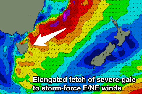
Both systems will strengthen through this weekend resulting in a persistent and slow moving fetch of severe-gale to storm-force winds to develop through the Tasman Sea, extending all the way south to our coasts.
No real considerable increase in size is due through tomorrow, with the fetch only really establishing through our swell window Saturday evening.
 We'll see this fetch projecting NE gales towards us through Sunday and Monday, kicking up a large and rapid increase in mid-period NE swell Sunday and then larger groundswell Monday.
Exposed north-east facing breaks are due to build to around 8-10ft by dark Sunday but with strengthening NE winds, with the groundswell filling in Monday with a couple of embedded pulses between 12-15ft.
E/NE gales will continue to be generated through our swell window Monday morning, resulting in the swell remaining large into Tuesday morning, easing back from 10-12ft or so.
Winds are still shifting around a lot for Monday and Tuesday with the dynamic and tricky nature of the system, but we're likely to see gale-force onshore NE winds severely limiting surfing options Monday with improving winds from the NW Tuesday.
This flows on into Wednesday and Thursday, but the swell event will be prolonged as the fetch of E/NE winds through our swell window persist until early Wednesday morning.
Winds look to swing straighter offshore, but more on this Monday. Have a great weekend!

