Strong NE swell due for the late weekend and early next week
Eastern Tasmania Surf Forecast by Guy Dixon (issued Monday 30th)
Best Days: Saturday morning and Monday morning at northeast facing beaches
Recap:
A great weekend of waves across northeast Tasmania over the weekend, with a solid 3-4ft swell on Saturday, easing to the 2-3ft range on Sunday and holding at a similar size today.
Quality has also been good each morning under a southwesterly breeze (Saturday and Sunday), more so northwesterly this morning. A light seabreeze came into play briefly on Saturday afternoon, more established this afternoon.
This week (Tuesday 31st - Friday 3rd):
The coming week is looking pretty quiet with the southern swell window taking a breather.
A few weak trailing fetches will push up through the Tasman Sea throughout the week, although their alignment is particularly poor, so only hints of refracted background energy are expected.
Otherwise, poorly aligned polar fronts are expected to continue through the southern swell window, limited by a particularly zonal nature. Once again, only background energy is likely to fill in across exposed south facing locations throughout the remainder of the forecast.
Tuesday morning may see a few 1-2ft stragglers off the back of today’s swell, but otherwise, options should otherwise ebb and pulse in the 1ft range throughout the week, with much better prospects due for the weekend.
Conditions should be clean each morning under a light northwesterly breeze, tending northeasterly each afternoon, not that there will be much swell to work with anyway.
This weekend (Saturday 4th - Sunday 5th) and next week (Monday 6th onward):
 A coastal trough looks to deepen off the NSW coast from around Wednesday and Thursday before interacting with a deep inland trough which is expected to move over central NSW on Friday. The interaction between this deep inland trough and a weakening ridge will cause the pressure gradient to increase from late on Friday afternoon.
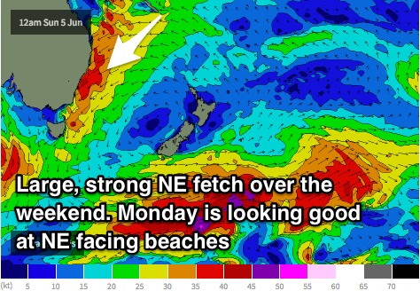
A large and elongated northeasterly fetch is likely to extend towards the islands of the South Pacific, increasing to a peak in strength and size on Sunday.
The resultant swell is due to build across nroth east facing beaches throughout Saturday to around 3-4ft, before kicking strongly throughout Sunday potentially into the double digits. A second intensification in this northerly fetch should maintain swell of a similar size on Monday, with northeast facing beaches copping the brunt of it.
Saturday morning should remain clean under a light northwesterly breeze, before tending onshore. Unfortunately, Sunday looks to be a write off under a gusty northeasterly breeze, improving on Monday morning as breezes tend offshore. This is the morning I’d aim for during the event.
More detail Wednesday.

