Very active period ahead
Eastern Tasmania Forecast by Craig Brokensha (issued Wednesday 8th April)
Best Days: Thursday morning, Friday morning, Saturday, later Sunday protected spots, Monday morning, Tuesday south facing beaches, Wednesday morning
Recap
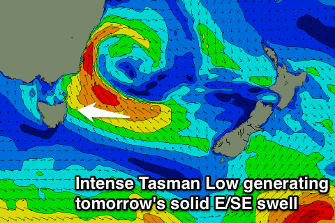
An inconsistent but fun E/NE swell to 2-3ft yesterday with protected southern corners the pick under S'ly winds. Today a building E/SE swell was coming in at a poor and average 3ft with onshore winds, and a further increase in size should have been seen during the day linked to a deep and powerful Tasman Low forming off the southern NSW coast and sitting directly east of us.
 This week and weekend (Apr 9 - 12)
Currently we have a deep and powerful Tasman Low centered just to our north-northeast, with an infeed of SE gales on its southern flank sitting within our swell window.
This low is expected to drift slowly east tomorrow opening up our swell window more to the fetch before winds swing more S/SE and out of our swell window tomorrow evening.
This should generate bigger levels of E/SE swell through tomorrow, peaking through the early afternoon to 4-6ft across open beaches. A steady drop in size is then due Friday from 3-5ft Friday morning, down further from 2ft+ Saturday morning.
Winds should improve and be fresh from the SW tomorrow morning, tending SE into the afternoon and then W/SW Friday morning ahead of afternoon sea breezes. Saturday looks great with W/NW offshores, swinging SW into the afternoon and then W/SW tending S'ly winds Sunday as a strong polar front pushes up past us, discussed in more detail below.
Later Sunday and Monday we're due to see a very large, strong and powerful S'ly groundswell pushing into the coast.
This will be related to a strong node (peak) of the Long Wave Trough moving across the southern Tasman Sea and then stalling over New Zealand during the weekend, projecting a vigorous polar frontal system up through our southern swell window and past our coast.
A broad and elongated fetch of severe-gale S/SW winds will be generated, producing a large long-period S'ly groundswell for on dark Sunday and more so Monday morning.
South facing beaches should build to 5-6ft by dark Sunday, peak overnight and then ease from 6ft+ Monday morning with larger sets at deepwater reefs and offshore bommies.
Winds Monday morning won't be ideal for south facing beaches with a W/SW tending S/SE breeze, but open beaches should be clean but a touch smaller.
The swell will then ease off steadily during the afternoon with some possible reinforcing S/SE groundswell pulses Tuesday/Wednesday, but we'll look more into this on Friday.

