Weak weekend swells, potential later next week
Eastern Tasmania Forecast by Craig Brokensha (issued Friday 27th March)
Best Days: Saturday morning south swell magnets, Sunday morning for small leftovers, Tuesday afternoon south swell magnets
Recap
Small to tiny and easing levels of swell from the NE yesterday, while today a sneaky pulse of NE swell which looks to have been produced from an infeed of NE winds into the low moving across us filled in. A strong S/SW change has since moved through though and whipped up a small S'ly windswell across south facing beaches.
 This weekend and next week (Mar 28 – Apr 3)
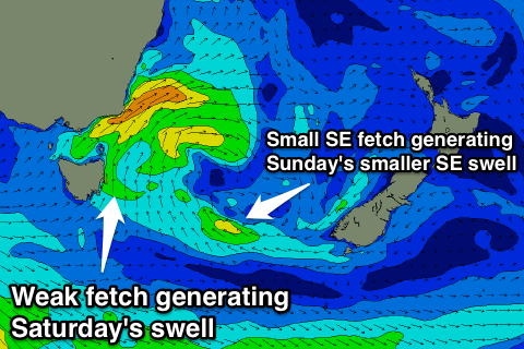
A relatively weak fetch of S/SE winds are being projected up our coast this afternoon and evening, with an infeed of SE winds more over towards New Zealand.
This fetch will swing away from us through tomorrow morning and as a result we should see a small easing S'ly swell from 2-3ft across south swell magnets tomorrow, becoming smaller from 1ft to occasionally 2ft out of the SE Sunday morning.
Winds look good tomorrow with light W'ly offshores developing through the morning ahead of NE sea breezes, while Sunday should see W/NW winds all day.
Into next week there's nothing too major initially, with a vigorous frontal progression generating a good swell for the South Arm Tuesday possibly showing at south swell magnets Tuesday afternoon to 2ft.
Into the end of the week though we may see a deepening surface trough pushing in from the west, developing into a low directly off our coast. This could see some chunky S/SE windswell developing Thursday/Friday but we'll have another look at this on Monday. Have a great weekend.

