Fading E'ly swell tomorrow, small NE windswell mid next week
Eastern Tasmania Forecast by Craig Brokensha (issued Friday 19th December)
Best Days: Saturday, Wednesday morning in protected southern corners
Recap
Yesterday was slower across the coast as we fell in between swells and today started off slow as well ahead of a strong pulse of E'ly groundswell to a long-lined 3ft on the sets. Winds went W'ly after early offshores limiting the best waves to southern corners.

This weekend (Dec 20 - 21)
Today's pulse of E'ly groundswell should peak this morning and then ease off through tomorrow from an inconsistent 2ft+ across open beaches under offshore W/NW winds.
Come Sunday there isn't expected to be much size left at all with fading 0.5-1ft sets. A small marginal spike in S'ly swell for the afternoon has been downgraded and we'll see the surf remain tiny after lunch.
Monday onwards (Dec 22 onwards)
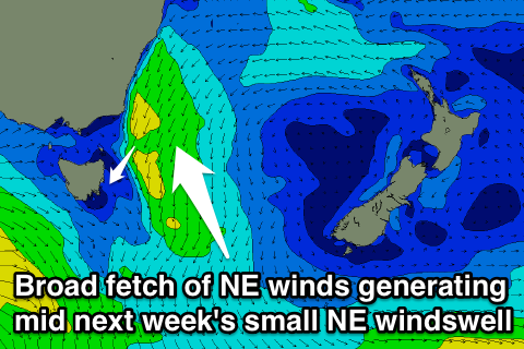
There's nothing major on the cards at all for next week with a NE windswell showing on the charts looking dicey. This is because the fetch of NE winds forming off the Southern NSW Coast won't really push down towards us, and this has me concerned that the swell will loose its energy by the time it hits us.
If there is any size to the swell, we should see inconsistent 1-2ft sets across north-east swell magnets into Tuesday afternoon and Wednesday morning before fading from 1ft Thursday.
Winds will be funky on Wednesday when the swell should be most visible with a fresh S/SE breeze, but this will favour southern corners. N'ly winds will then kick in Thursday creating poor conditions.
Longer term there's nothing major showing on the chars unfortunately so make the most of today's swell and get the last of it early tomorrow! Have a great weekend!

