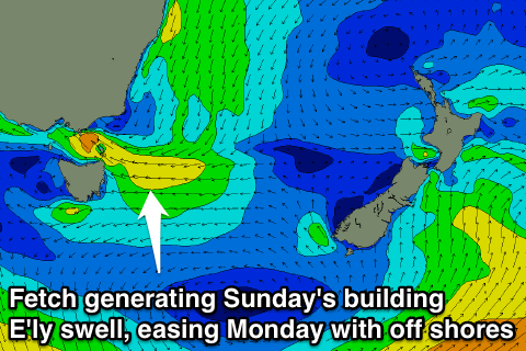
Clean rapidly easing E'ly swell Monday
Eastern Tasmania Forecast by Craig Brokensha (issued Friday 5th December)
Best Days: Monday morning, Tuesday in southern corners, Wednesday morning
Recap
Yesterday was small and onshore leaving no options for a wave, while a kick in E/SE windswell with lighter SE winds opened up some fun 2-3ft waves for keen surfers this morning.
 This weekend and next week (Dec 6 - 12)
A deepening trough slipping south-east away from us is the system responsible for today's swell and through tomorrow we'll see a fetch of strong S/SE winds generated as it continues to move off to the south-east. This should kick up a weak windswell through the day mixed in with a slightly stronger SE swell from the bottom flank of the trough, building to 2-3ft through the afternoon across open beaches from 2ft during the morning.
Of greater importance is a stronger and deeper trough following a similar pattern but producing a larger E/SE tending E'ly swell through Sunday and Monday.
This trough is forecast to generate a fetch of strong to gale-force E/SE winds through our swell window Sunday kicking up 3-5ft of E/SE swell through the afternoon and into the evening. Conditions will be poor though as the trough moves down the coast bringing strong E/SE winds.
Into Monday though the trough will be dipping south-east and away from us resulting in winds swinging offshore from the W/SW with a pumping 3-4ft of easing swell.
Get in early though as the swell will ease rapidly through the day once winds go offshore.
Into the rest of the week distant and small levels of E/NE trade-swell should keep exposed beaches topped up with inconsistent 2ft sets Tuesday and Wednesday before fading through Thursday.
We'll look at this in closer detail on Monday though. Have a great weekend!

